Want to create or adapt books like this? Learn more about how Pressbooks supports open publishing practices.
14
Dr. Maya Jiménez; Dr. Lauren Kilroy-Ewbank; Lumen Learning; British Museum; Dr. Sarahh Scher; Jayne Yantz; Dr. Naraelle Hohensee; Lois Martin; Dr. Steven Zucker; and Dr. Katherine T. Brown
The routes of the four Voyages of Christopher Columbus, 1492-1504 to the Caribbean Islands and the coast of Central America (image, CC BY-SA 3.0)
What does “pre-Columbian” mean?
The original inhabitants of the Americas traveled across what is now known as the Bering Strait, a passage that connected the westernmost point of North America with the easternmost point of Asia. The Western hemisphere was disconnected from Asia at the end of the last Ice Age, around 10,000 B.C.E.
In 1492, the Genoese explorer Christopher Columbus arrived at the islands of Cuba and Hispaniola (today Haiti and the Dominican Republic), mistakenly thinking he had reached Asia. Columbus’ miscalculation marked the first step in the colonization of the Americas, or what was then seen as a “New World.” Incorrectly referring to the native inhabitants of Hispaniola as “Indians” (under the assumption that he had landed in India), Columbus established the first Spanish colony of the Americas. “Pre-Columbian” thus refers to the period in the Americas before the arrival of Columbus.
Pyramid of the Sun, Teōtīhuacān. Teōtīhuacān reached its peak from the 1st to the mid-6th century C.E. The main structures include the Pyramids of the Sun and the Moon, Avenue of the Dead, and the Temple of Quetzalcoatl (feathered serpent). Teotihuacan was home to as many as 125,000 people. The name Teōtīhuacān was given by the Aztecs long after the city had been abandoned in c. 550 C.E. The original name is lost.
The Spanish conquistadores (conquerors) found that the “New World” was in fact not new at all, and that the indigenous people of Mesoamerica had established advanced civilizations with densely populated cities and towering architectural monuments such as at Teōtīhuacān, as well as advanced writing systems.
The term pre-Columbian is complicated however. For one thing, although it refers to the indigenous peoples of the Americas, the phrase does not directly reference any of the many sophisticated cultures that flourished in the Americas (think of the Aztec, Inka, or Maya, to name only a few) and instead invokes a European explorer. For this reason and because indigenous peoples flourished before and after the arrival of the Europeans, the term is often seen as flawed. Other terms such as pre-Hispanic, pre-Cortesian, or more simply, ancient Americas, are sometimes used.
Cylindrical vessel with ball game scene, c. 682-701 C.E., Late Classic, Maya, ceramic, 20.48 cm high (Dallas Museum of Art)(zoomable image here)
Cylindrical vessel with ball game scene, c. 682-701 C.E., Late Classic, Maya, ceramic, 20.48 cm high (Dallas Museum of Art) (zoomable image here)
What does “Mesoamerica” mean?
The region of Mesoamerica—which today includes central and south Mexico, Belize, Guatemala, and the western portions of Honduras and El Salvador—consists of a diverse geographic landscape of highlands, jungles, valleys, and coastlines. Mesoamericans did not exploit technological innovations such as the wheel—though they were used in toys— and did not develop metal tools or metalworking techniques until at least until 900 C.E. Instead, Mesoamerican artists are known for producing megalithic (large stone) sculpture and extremely sharp weapons from obsidian (volcanic glass). Featherwork and stonework in basalt, turquoise, and jade dominated Mesoamerican artistic production, while exceptional textiles and metallurgy flourished further south, among pre-Columbian Andean and Central American cultures, respectively.
Pre-Columbian Mesoamerican cultures shared certain characteristics such as the ritual ballgame,* pyramid building, human sacrifice, maize as an agricultural staple, and deities dedicated to natural forces (i.e. rain, storm, fire). Additionally, some Mesoamerican societies developed sophisticated systems of writing, as well as an advanced understanding of astronomy (which allowed for the development of accurate and complex calendar systems, including the 260-day sacred calendar and the 365-day agricultural calendar). As a result, cities like La Venta and Chichen Itza were aligned in relation to cardinal directions and had a sacred center. The fact that many of these cultural trademarks persisted for more than 2,000 years across civilizations as distinct as the Olmec (c. 1200–400 B.C.E.) and the Aztec (c. 1345 to 1521 C.E.), demonstrates the strong cultural bond of Mesoamerican cultures.
El Tajín Ball Court, c. 800 – 1200 C.E., Classic Veracruz Culture (photo: Oscar Zorrilla Alonso, CC BY-SA 2.0)
*The ballgame was played in different iterations at different times and in different places. It was played with a rubber ball that players hit with their elbows, hips, or knees. The ballgame was considered an important ritual in Mesoamerica and was practiced first by the Olmec and last by the Aztec. Since the rubber ball was solid and heavy, players wore protective gear to avoid injury and may have tried to score the ball through a ring, which was usually located high on the wall of the ballcourt. Numerous rubber balls and ballcourts have been discovered throughout Mesoamerica in El Tajín (image above) and Monte Albán, although the largest surviving ballcourt is located in Chichen Itza. While the ballgame was played by the elite, it was believed that the fate of the game and thus of the player was determined by the gods. As a result, the Mesoamerican ballgame held significant implications. Learn more about the ballgame here.
Avocado, tomato, and chocolate. You are likely familiar with at least some of these food items. Did you know that they all originally come from Mexico, and are all based on Nahuatl words (ahuacatl, tomatl, and chocolatl) that were eventually adopted by the English language?
Nahuatl is the language spoken by the Nahua ethnic group that is found today in Mexico, but with deep historical roots. You might know one Nahua group: the Aztecs, more accurately called the Mexica. The Mexica were one of many Mesoamerican cultural groups that flourished in Mexico prior to the arrival of Europeans in the sixteenth century.
Map of Mesoamerica, with the borders of modern countries
Where was Mesoamerica?
Mesoamerica refers to the diverse civilizations that shared similar cultural characteristics in the geographic areas comprising the modern-day countries of Mexico, Guatemala, Honduras, Belize, El Salvador, Nicaragua, and Costa Rica. Some of the shared cultural traits among Mesoamerican peoples included a complex pantheon of deities, architectural features, a ballgame, the 260-day calendar, trade, food (especially a reliance on maize, beans, and squash), dress, and accoutrements (such as earspools).
Some of the most well-known Mesoamerican cultures are the Olmec, Maya, Zapotec, Teotihuacan, Mixtec, and Mexica (or Aztec). The geography of Mesoamerica is incredibly diverse—it includes humid tropical areas, dry deserts, high mountainous terrain, and low coastal plains. An anthropologist named Paul Kirchkoff first used the term “Mesoamerica” (meso is Greek for “middle” or “intermediate”) in 1943 to designate these geographical areas as having shared cultural traits prior to the invasion of Europeans, and the term has remained.
Typically when we discuss Mesoamerican art we are referring to art made by peoples in Mexico and much of Central America. When people mention Native North American art, they are usually referring to indigenous peoples in the U.S. and Canada, even though these countries are technically all part of North America. More recently, archaeologists and art historians have considered connections between the Southwestern and Southeastern U.S. and Mesoamerica, an area sometimes called either the Greater Southwest or Greater Mesoamerica. Focusing on these connections demonstrates how people were in contact with one another through trade, shared beliefs, migration, or conflict. Ball courts, for instance, are found in Arizona sites such as the Pueblo Grande of the Hohokam. It is important to remember that modern-day geographic terms—like Mesoamerica or the Southwestern U.S.—are recent designations.
This essay generalizes about Mesoamerican cultures, but keep in mind that each possessed unique qualities and cultural differences. Mesoamerica was not homogenous.
When was Mesoamerica?
Art historians and archaeologists divide Mesoamerican history into distinct periods and some of these periods are then further divided into the sub-periods—early, middle, and late.
Period
Dates
Cultures
Archaic Period
c. 3500-1500 BCE
Pre-Classical (or Formative) Period
c. 1800 BCE-250 CE
Olmec, Teotihuacan, Tlatilco, Maya, Zapotec
Classic Period
c. 150-650 CE
Teotihuacan, Maya
Epiclassic Period
c. 650-900 CE
Maya, Toltec
Postclassic Period
c. 900-1519 CE
Toltec, Aztec (Mexica), Mixtec, Maya
The date for the end of the Postclassic period is somewhat contested as it presumes that Mesoamerican culture largely ended with the arrival of Spaniards into the Mexica capital of Tenochtitlan in 1519, though Mesoamerican culture continued under Spanish control, albeit significantly transformed.You might also encounter the term Pre-Columbian, which is a term designating indigenous cultures prior to the arrival of Columbus. It includes those in Mesoamerica, as well as in South America and the Caribbean. This term is problematic for several reasons, and is explored in another essay.
What language did people speak?
There was no single language that united the peoples of Mesoamerica. Linguists believe that Mesoamericans spoke more than 125 different languages. For instance, Maya peoples did not speak “Mayan”, but could have spoken Yucatec Maya, K’iche, or Tzotzil among many others. The Mexica belonged to the bigger Nahua ethnic group, and therefore spoke Nahuatl.
Map of indigenous languages in Mexico with more than 100,000 speakers
To students learning about Mesoamerica for the first time, the incredible diversity of people, languages, and even deities can be overwhelming. I recall my first Mesoamerican art history class vividly. I was intimidated by my lack of familiarity with different Mesoamerican words, languages, and cultural groups. By the end of the semester I was proud that I could differentiate between the Zapotec and Mixtec, and could spell Tlaloc. It took me a few more years to be able to spell and pronounce words like Tlacaxipehualiztli (Tla-cawsh-ee-pay-wal-eeezt-li) or Huitzilopochtli (Wheat-zil-oh-poach-lee).
Writing
Mesoamerican writing systems vary by culture. Rebus writing (writing with images) was common among many groups, like the Nahua and Mixtec. Imagine drawing an eye, a heart, and an apple. You’ve just used rebus writing to communicate “I love apples” to anyone familiar with these symbols. Many visual writing systems in Mesoamerica functioned similarly—although the previous example was simplified for the sake of clarity. You might encounter the phrases “writing without words” or “writing with signs” used to describe many writing systems in Mesoamerica. It is also called pictographic, ideographic, or picture writing.
Marriage between Lord 8 Deer and Lady 13 Serpent in the Codex Zouche-Nuttall, c. 1450 CE, Mixtec (or Ñudzavui), Late Postclassic period, deerskin, folio 27 (The British Museum)
Only the Maya used a writing system like ours, where signs like letters designate sounds and syllables, and combined together to create words. Maya hieroglyphic writing is logographic, which means it uses a sign (think of a picture, symbol, or a letter) to communicate a syllable or a word.
The 260-day ritual calendar vs. the 365-day calendar
Other shared features among Mesoamerican peoples were the 260-day and 365-day calendars. The 260-day calendar was a ritual calendar, with 20 months of 13 days. Based on the sun, the 365-day calendar had 18 months of 20 days, with five “extra” nameless days at the end. It was the count of time used for agriculture.
Imagine both of these calendars as interlocking wheels. Every 52 years they completed a full cycle, and during this time special rituals commemorated the cycle. For example, the Mexica celebrated the New Fire Ceremony as a period of renewal. These cycles were understood as life cycles, and so reflect creation, death, and rebirth. The Maya (especially during the Classic period), also used a Long Count calendar in addition to the two already mentioned (rather than a cyclical calendar, the Long Count marked time as if along an extended line that does not repeat).
Religion and pantheon of gods
A complex pantheon of gods existed within each Mesoamerican culture. Many groups shared similar deities, although there was a great deal of variation. Deities that had important roles across Mesoamerica included a storm/rain god and a feathered serpent deity. Among the Mexica, this storm/rain god was known as Tlaloc, and the feathered serpent deity was known as Quetzalcoatl. The Maya referred to their storm/rain deity as Chaac (there are multiple spellings). The equivalent of Quetzalcoatl among different Maya groups included Kukulkan (Yucatec Maya) and Q’uq’umatz (K’iche Maya). Cocijo is the Zapotec equivalent of the storm/rain god. Many artworks exist that show these two deities with similar features. The storm/rain deity often has goggle eyes and an upturned mouth/snout. Feathered serpent deities typically showed serpent features paired with feathers.
Quetzalcoatl (Feathered Serpent), c. 1321-1521, 210 x 440 cm (National Museum of Anthropology, Mexico)
It is difficult to generalize about Mesoamerican religious beliefs and cosmological ideas because they were so complex. Throughout Mesoamerica, there was a general belief in the universe’s division along two axes: one vertical, the other horizontal. At the center, where these two axes meet, is the axis mundi, or the center (or navel) of the universe. On the horizontal plane, four directions branch off from the axis mundi. Think of the four cardinal directions (north, south, east, and west). On the vertical plane, we generally find the world split into three major realms: the celestial, terrestrial, and underworld.
Codex Féjervary-Mayer, 15th century, f. 1 (World Museum, Liverpool)
One Mexica example helps to clarify this complex cosmological system. An image in the Codex Féjervary-Mayer displays the cosmos’s horizontal axis. In the center is the deity Xiuhtecuhtli (a fire god), standing in the place of the axis mundi. Four nodes (what look almost like trapezoidal petals) branch off from his position, creating a shape called a Maltese Cross. East (top) is associated with red, south (right) with green, west (bottom) with blue, and north (left) with yellow. A specific plant and bird accompany each world direction: blue tree and quetzal (east), cacao and parrot (south), maize and blue-painted bird (west), and cactus and eagle (north). Two figures flank the plant in each arm of the cross. Together, these figures and Xiuhtecuhtli represent the Nine Lords of the Night. This cosmogram describes how the Mexica conceived of the universe.
Ball Court Model, Mexico, Nayarit, c. 200 B.C.E.–500 C.E., ceramic with slip and other pigments, 15.24 x 21.59 x 34.29 cm (Los Angeles County Museum of Art)
The ballgame
Peoples across Mesoamerica, beginning with the Olmecs, played a ritual sport known as the ballgame. Ballcourts were often located in a city’s sacred precinct, emphasizing the importance of the game. Solid rubber balls were passed between players (no hands allowed!), with the goal of hitting them through markers. Players wore padded garments to protect their bodies from the hard ball.
The meanings of the ballgame were many and varied. It could symbolize a range of larger cosmological ideas, including the movement of the sun through the underworld every night. War captives also played the game against members of a winning city or group, with the game symbolizing their defeat in war. Sometimes a game was even played instead of going to war.
Numerous objects display aspects of the ballgame, attesting to its significant role across Mesoamerica. We have examples of clay sculptures of ballgames occurring on courts. Ballplayers are also frequent subjects in Maya painted ceramic vessels and sculptures. Stone reliefs at El Tajin and Chichen Itza depict different moments of a ballgame culminating in ritual sacrifice. Painted pictorial codices, such as the Codex Borgia (above), display I-shaped ballcourts, and stone depictions of ballgame clothing have been found. Today, people in Mexico still play a version of the ballgame.
I-shaped ballcourt, Codex Borgia, c. 1500, f. 42 (Vatican Library)
Mesoamerican societies continue to impress us with their sophistication and accomplishments, notably their artistic achievements. Our understanding continues to expand with ongoing research and archaeological excavations. Recent excavations in Mexico City, for instance, uncovered a new monumental Mexica sculpture buried with some of the most unique objects we’ve ever seen in Mexica art. With these discoveries, our understanding of the Mexica will no doubt grow and change.
Ballcourt at the Wupatki National Monument, Arizona. Wupatki, c. 750-1200. Photo: Dr. Cerise Myers
Editor’s note: There are ballcourts closer to us here in California than El Tajin and Chichen Itza, as the tradition made its way, with variations, into North America. Here is a photograph of the reconstructed remains of a ballcourt at the Wupatki National Monument near Flagstaff, Arizona. More than 200 of these ballcourts, built between 750-1200 CE, have been discovered in Arizona, suggesting their importance for the Wupatki and their southern neighbors, who likely “borrowed and modified the ballcourt idea from earlier contact” with the native cultures of Mexico. [Wupatki National Monument signage]
Seated Bench Figure, Serpentine, Olmec. Serpentine, 11.3 x 5.7 x 5.4cm, 10th-4th century BCE. The Metropolitan Museum of Art.
Mesoamerica was dominated by three cultures in the Pre-Classical (up to 200 CE) to Post-Classical periods (circa 1580 CE): the Olmec, Maya, and Aztec. Mesoamerica is a region in the Americas that extends from central Mexico to northern Costa Rica. Three cultures dominated the pre-Columbian history of Mesoamerica: the Olmec, Maya, and Aztec civilizations.
Olmec Culture
The Olmec civilization, which flourished from 1200–400 BCE, defines the Pre- Classical period; the Olmecs are generally considered the forerunner of all Mesoamerica cultures including the Maya and Aztecs. Primarily centered in the modern states of Tabasco and Veracruz in the Gulf of Mexico, the Olmec people are known for creating an abundance of small and extraordinarily detailed jade figurines. The figurines typically exhibit complex shapes such as human figures, human-animal composites of deities and gods, and animals like cats and birds. Although we don’t know the specific purpose of these jade objects, their presence in some Olmec graves suggests they served a religious purpose in addition to being signs of wealth and goods for trade.
The Olmec are also known for building massive stone sculptures, many of which were discovered at La Venta in the modern Mexican state of Tabasco. Made from basalt rock from the Tuxtla mountains to the north, the Olmec used this rock to create altars, stelae, and colossal heads. Each head is rendered as a distinct individual and is thought to resemble an Olmec ruler. Each ruler’s personality is represented in the distinct headdresses that adorn the sculptures’ heads.
Colossal head, Olmec, La Venta, Mexico, 900-400 BCE. Basalt, 9’4″ high. Villhermosa Museum. (Photo: Glysiak, CC BY SA 4.0)
These massive basalt boulders were transported from the Sierra de los Tuxtlas Mountains of Veracruz. When originally displayed in Olmec centers, the heads were arranged in lines or groups; however, the method used to transport the stone to these sites remains unclear. Given the enormous weight of the stones and the manpower required to transport them over large distances, it is probable that the colossal portraits represent powerful Olmec rulers. The colossal heads range in height from 5 to 12 feet and portray adult males wearing close-fitting caps with chin straps and large, round earspools. The fleshy faces have almond-shaped eyes, flat, broad noses, thick, protruding lips, and downturned mouths. Each face has a distinct personality, suggesting that they represent specific individuals.
The discovery of a colossal head at Tres Zapotes in the nineteenth century spurred the first archaeological investigations of Olmec culture by Matthew Stirling in 1938. Seventeen confirmed examples are traced to four sites within the Olmec heartland on the Gulf Coast of Mexico. Most colossal heads were sculpted from spherical boulders, but two from San Lorenzo Tenochtitlán were recarved from massive stone thrones. An additional monument at Takalik Abaj in Guatemala is a throne that may have been carved from a colossal head. This is the only known example from outside the Olmec heartland.
Dating the monuments remains difficult because of the movement of many from their original contexts prior to archaeological investigation. Most have been dated to the Early Preclassic (or Formative) period (1500–1000 BCE) with some to the Middle Preclassic (1000–400 BCE) period. The smallest weighs six tons, while the largest is estimated to weigh 40 to 50 tons, although it was abandoned and left unfinished close to the source of its stone.
Teotihuacan
At its height, Teotihuacan was one of the largest cities in the world with a population of 200,000. It was a primary center of commerce and manufacturing. Located some 30 miles northeast of present-day Mexico City, Teotihuacan experienced a period of rapid growth early in the first millennium CE. By 200 CE, it emerged as a significant center of commerce and manufacturing, the first large city-state in the Americas. At its height between 350 and 650 CE, Teotihuacan covered nearly nine miles and had a population of about 200,000, making it one of the largest cities in the world. One reason for its dominance was its control of the market for high-quality obsidian. This volcanic stone, made into tools and vessels, was traded for luxury items such as the green feathers of the quetzal bird, used for priestly headdresses, and the spotted fur of the jaguar, used for ceremonial garments.
The people of Teotihuacan worshipped deities that were recognizably similar to those worshipped by later Mesoamerican people, including the Aztecs, who dominated central Mexico at the time of the Spanish Conquest. Among these are the Rain or Storm God (god of fertility, war, and sacrifice), known to the Aztecs as Tlaloc, and the Feathered Serpent, known to the Maya as Kukulcan and to the Aztecs as Quetzalcoatl.
Ceremonial center of the city of Teotihuacan, Mexico, Teotihuacan culture, c. 350-650 CE.: View from the Pyramid of the Moon down the Avenue of the Dead to the Ciudadela and the Temple of the Feathered Serpent. The Pyramid of the Sun is at the middle left. The avenue is over a mile long.Temple of the Feathered Serpent, the Ciudadela.: Detail of pyramid, showing the alternating talud base and vertical tablero (left).
Teotihuacan’s principal monuments include the Pyramid of the Sun, the Pyramid of the Moon, and the Ciudadela (Spanish for fortified city center), a vast sunken plaza surrounded by temple platforms. The city’s principal religious and political center, the Ciudadela could accommodate an assembly of more than 60,000 people. Its focal point was the pyramidal Temple of the Feathered Serpent. This seven-tiered structure exhibits the talud-tablero construction that is a hallmark of the Teotihuacan architectural style. The sloping base, or talud, of each platform supports a vertical tablero, or entablature, which is surrounded by frame and filled with sculptural decoration. The Temple of the Feathered Serpent was enlarged several times, and as was characteristic of Mesoamerican pyramids, each enlargement completely enclosed the previous structure like the layers of an onion. Archaeological excavation of this temple’s earlier-phase tableros and a stairway balustrade have revealed painted heads of the Feathered Serpent, the goggle-eyed Rain or Storm God, and reliefs of aquatic shells and snails. The flat, angular, abstract style, typical of Teotihuacan art, is in marked contrast to the curvilinear style of Olmec art.
The Decline
Sometime in the middle of the seventh century disaster struck Teotihuacan. The ceremonial center burned and the city went into a permanent decline. Nevertheless, its influence continued as other centers throughout Mesoamerica and as far south as the highlands of Guatemala borrowed and transformed its imagery over the next several centuries. The site was never entirely abandoned as it remained a legendary pilgrimage center. The much later Aztec people (c. 1300-1525 CE) revered the site as the place where they believed the gods created the sun and the moon. In fact, the name “Teotihuacan” is actually an Aztec word meaning “Gathering Place of the Gods.”
Mayan Art
Mayan art includes a wide variety of objects, commissioned by rulers, that depict scenes of both elite and everyday society.
Mayan Portraiture
Stele H portraying the ruler 18-Rabbit. Great Plaza at Copan, Honduras. Made of stone, 11′ 9″ high. : Although a powerful ruler, 18-Rabbit eventually was captured and beheaded by a rival king.
Strong cultural influences stemming from the Olmec tradition and Teotihuacan contributed to the development of the Mayan city center and the culture’s Classic artistic tradition. The most sacred and majestic buildings of Mayan cities were built in enclosed, centrally located precincts. The Maya held dramatic rituals within these highly sculptured and painted environments. For example, the grand pyramids of Copan and Tikal are among the most imposing buildings the Maya erected; each contains sculpted portraits that glorified the city’s rulers.
Stele H in the Great Plaza at Copan represents one of the city’s foremost leaders, 18-Rabbit, who reigned from 695-738 CE. During the ruler’s long reign, Copan reached its greatest physical extent and breadth of political influence. On Stele H, 18-Rabbit wears an elaborate headdress and ornamented kilt and sandals. He holds across his chest a double-headed serpent bar, symbol of the sky and of his absolute power. His features, although idealized, have the quality of a portrait likeness. The Mayan elite, like the Egyptian pharaohs, tended to have themselves portrayed as eternally youthful. The dense, deeply carved ornamental details that frame the face and figure stand almost clear of the main stone block and wrap around the sides of the stele. The stele was originally painted, with remnants of red paint visible on many stelae and buildings in Copan.
Clay Sculpture
Costumed Figure, Maya, 7th-8th century. Ceramic, pigment, 11 1/2″ tall. The base for this figurine, which is also a whistle, was produced in a mold, with individual details added by hand. It was originally even more brightly colored, and still retains some of its color, including the “Maya blue.” (The Metropolitan Museum of Art, New York)
Many small clay figures from the Classic Mayan period remain in existence. These free-standing objects illustrate aspects of everyday Mayan life. As a group, they are remarkably life-like, carefully descriptive, and even comic at times. They represent a wider range of human types and activities than commonly depicted on Mayan stelae. Ball players, women weaving, older men, dwarves, supernatural beings, and amorous couples, as well as elaborately attired rulers and warriors, comprise one of the largest groups of surviving Mayan art. Many of the hollow figurines are also whistles. They were made in ceramic workshops and painted with Maya Blue, a dye unique to Mayan and Aztec artists. Small clay figures found in burial sites were made to accompany the Mayan dead on their inevitable voyage to the Underworld.
The Maya painted vivid narrative scenes on the surfaces of cylindrical vases. A typical vase design depicts a palace scene where an enthroned Mayan ruler sits surrounded by courtiers and attendants. The figures wear simple loincloths, turbans of wrapped cloth and feathers, and black body paint. These painted vases may have been used as drinking and food vessels for noble Maya, but their final destination was the tomb, where they accompanied the deceased to the Underworld. They likely were commissioned by the deceased before his death or by his survivors, and were occasionally sent from distant sites as funerary offerings.
Mayan Architecture
The Maya had complex architectural programs. They built imposing pyramids, temples, palaces, and administrative structures in densely populated cities.
Architecture in Palenque
Palace (right) and Temple of the Inscriptions, tomb-pyramid of Lord Pakal (left) : Palenque, Mexico. Mayan culture, late 7th century.
In Palenque, Mexico, a prominent city of the Classic period, the major buildings are grouped on high ground. The central group of structures includes the Palace (possibly an administrative and ceremonial center as well as a residential structure), the Temple of the Inscriptions, and two other temples. Most of the structures in the complex were commissioned by a powerful ruler, Lord Pakal, who reigned from 615 to 638 CE, and his two sons, who succeeded him.
Temple of the Inscriptions
Temple of the Inscriptions (tomb pyramid of Lord Pakal) : Palenque, Mexico, 7th century. (Photo: Lousanroj, CC BY SA 3.0)
The Temple of the Inscriptions is a nine-level pyramid that rises to a height of about 75 feet. The consecutive layers probably reflect the belief, current among the Aztec and Maya at the time of the Spanish conquest, that the underworld had nine levels. Priests would climb the steep stone staircase on the exterior to reach the temple on top, which recalls the kind of pole-and-thatch houses the Maya still build in parts of the Yucatan today. The roof of the temple was topped with a crest known as a roof comb, and its façade still retains much of its stucco sculpture. Inscriptions line the back wall of the outer chamber, giving the temple its name.
The Palace
The Palace’s Observation Tower with mansard roof : Palenque, Mexico, late Classic period. (Photo: Ricraider, CC BY SA 3.0)
Across from the Temple of Inscriptions is the Palace, a complex of several adjacent buildings and courtyards built on a wide artificial terrace. The Palace was used by the Mayan aristocracy for bureaucratic functions, entertainment, and ritual ceremonies.
Numerous sculptures and bas-relief carvings within the Palace have been conserved. The Palace’s most unusual and recognizable feature is the four-story tower known as the Observation Tower. Like many other buildings at the site, the Observation Tower exhibits a mansard roof. The Palace was equipped with numerous large baths and saunas which were supplied with fresh water by an intricate water system. An aqueduct constructed of great stone blocks with a six-foot-high vault diverts the Otulum River to flow underneath the main plaza.
Architecture in Chichen Itza
As the focus of Maya civilization shifted northward in the Postclassic period, a northern Maya group called the Itza rose to prominence. Their principal center, Chichen Itza, (Yucatan State) Mexico, which means “at the mouth of the well of the Itza,” flourished from the 9th to 13th centuries CE, eventually covering about six square miles.
El Castillo
One of Chichen Itza’s most conspicuous structures is El Castillo (Spanish for the castle), a massive nine-level pyramid in the center of a large plaza with a stairway on each side leading to a square temple on the pyramid’s summit. At the spring and fall equinoxes, the setting sun casts an undulating, serpent-like shadow on the stairways, forming bodies for the serpent heads carved at the base of the balustrades.
“El Castillo” (the Castle) (Temple of Kukulcán). Chichen Itza, Yucatan, Mexico. 9th-13th century. (Photo: Alastair Rae, CC By SA 2.0)Shadows cast on Kukulcán during Equinox at Chichen Itza. (Photo: ATSZ56, public domain)
The Great Ball Court
The Great Ball Court northwest of the Castillo is the largest and best preserved court for playing the Mesoamerican ball game, an important sport with ritual associations played by Mesoamericans since 1400 BCE. The parallel platforms flanking the main playing area are each 312 feet long. The walls of these platforms stand 26 feet high. Rings carved with intertwined feathered serpents are set high at the top of each wall at the center. At the base of the interior walls are slanted benches with sculpted panels of teams of ball players. In one panel, one of the players has been decapitated; the wound spews streams of blood in the form of wriggling snakes.
The Great Ball Court, Chichen Itza, Mexico Late Classic period, 551′ x 230′: The modern version of the Mesoamerican ball game is called Ulama and is similar to racquetball. (Photo: Bjørn Christian Tørrissen, CC BY SA 3.0)
At one end of the Great Ball Court is the North Temple, also known as the Temple of the Bearded Man (Templo del Hombre Barbado). This small masonry building has detailed bas-relief carving on the inner walls, including a center figure with decorative carvings that resemble facial hair. Built into the east wall are the Temples of the Jaguar. The Upper Temple of the Jaguar overlooks the ball court and has an entrance guarded by two large columns carved in the familiar feathered serpent motif. At the entrance to the Lower Temple of the Jaguar is another Jaguar throne similar to the one in the inner temple of El Castillo.
Ceramics of the Veracruz
Ceramic figurines are a hallmark of Classic Veracruz art. The Veracruz people produced a variety of small clay figures in multiple areas around the modern state of Veracruz, Mexico.
The modern state of Veracruz lies along the Mexican Gulf Coast, north of the Maya lowlands and east of the highlands of central Mexico. Culturally diverse and environmentally rich, the people of Veracruz took part in dynamic interchanges between three regions that over the centuries included trade, warfare, and migration. During the middle centuries of the first millennium, the artistically gifted Veracruzanos created inventive ceramic sculpture in diverse yet related styles.
Until the early 1950s, Classic Veracruz ceramics were few, little understood, and generally without provenance (known history). Since then, the recovery of thousands of figurines and pottery pieces from sites such as Remojadas and Nopiloa (some initially found by looters), has expanded our understanding and filled many museum shelves. Artist and art historian Miguel Covarrubias described Classic Veracruz ceramics as “powerful and expressive, endowed with a charm and sensibility unprecedented in other, more formal cultures.”
Remojadas-style figurines, perhaps the most easily recognizable from this culture, are usually hand-modeled and often adorned with appliqués. Of particular note are the Sonrientes (Smiling) Figurines, with triangular-shaped heads and outstretched arms. Figurines from Nopiloa are often molded and usually less ornate, without appliqués. The Figure from Nopiloa provides scholars with an example of the clothing worn in ancient times, such as the loincloth and headdress. The flattened forehead on this smiling figure may represent the practice of intentional cranial deformation or may simply reflect an artistic convention. Many American cultures considered a flattened forehead desirable and used a variety of techniques to flatten the skulls of infants while they were still pliable.
“Smiling” Figure, Late Classic Period, 7th–8th century: Remojadas, Veracruz, Mexico, 45 cm high (The Metropolitan Museum of Art)
Another smiling figure from the Remojadas region is a hollow ceramic sculpture representing an individual celebrating with music and dance. This bare-chested figure with open mouth and filed teeth stands energetically with legs spread and arms lifted as if caught in mid-motion. He wears a woven cap with geometric patterns, an elaborate skirt, circular earrings, a beaded necklace, and a bracelet. His face and body contain patterns evocative of body paint, including slight lines emanating from his lower eyelids and onto his cheeks. This sculpture evokes a festive dance or ritual accompanied by the rhythmic reverberation of the hand-held rattle and celebratory sound escaping from the figure’s open mouth.
In contrast to Smiling Figures from Remojadas, the mold-made ceramic figure from Nopiloa depicts a bearded, mustachioed male wearing a ballgame yoke around his waist to protect him from the hard, solid rubber ball used in play. There are cylindrical ear ornaments in his ears and beneath his arm, a baton-like object perhaps related to the local incarnation of the game. The rules and manner in which the Mesoamerican ballgame was played varied among contemporary sites and evolved through time. Surviving evidence suggests human sacrifice was a frequent outcome, but the game may also have been played for other purposes such as sport. The people of ancient Veracruz interacted with people from other Mesoamerican cultures, and this Nopiloa figure displays motifs commonly found in Mayan art. Knotted ties like those around this player’s wrist and neck connote captured prisoners in Mayan pictorial language. A motif similar to the Maya mat, a symbol of rulership, appears on the flanged headdress of the ballplayer. Like Mayan figurines of this type, the body of this figure is a whistle, a musical instrument used in ritual and ceremony.
Ball Player Figurine, 7th–10th century, Nopiloa, Veracruz, Mexico, 27 cm. high.: Nopiloa, Veracruz, Mexico. 27 centimeters high. (Metropolitan Museum of Art)
Mixtec Art
The Mixtecs were one of the most influential ethnic groups to emerge in Mesoamerica during the Post-Classic period. Never a united nation, the Mixtecs waged war and forged alliances among themselves as well as with other peoples in their vicinity. They also produced beautiful manuscripts and metal work and influenced the international artistic style used from Central Mexico to Yucatan.
During the Classic period, the Mixtecs lived in hilltop settlements of northwestern Oaxaca, a fact reflected in their name in their own language, Ñuudzahui, meaning “People of the Rain.” During the Post-Classic period, the Mixtecs slowly moved into adjacent valleys and then into the great Valley of Oaxaca. This time of expansion is recorded in a large number of deerskin manuscripts called codices, only eight of which have survived. Nevertheless, these manuscripts allow us to trace Mixtec history from 1550 CE back to 940 CE, deeper in time than any other Mesoamerican culture except the Maya.
Mixtec Codices
Mixtec Codex Zouche-Nuttall: Mixtec codices were made of deerskin and folded like an accordion.
Mixtec codices represent a type of writing classified as logographic, meaning the characters and pictures used represent complete words and ideas instead of syllables or sounds. In Mixtec, the relationships among pictorial elements denote the meaning of the text, whereas in other Mesoamerican writing the pictorial representations are not incorporated into the text. Common topics found in the codices are biographies of rulers and other influential figures, records of elite family trees, mythologies, and accounts of ceremonies.
A Warrior Scene from the Codex Zouche-Nuttall.
The detail from the Codex Zouche-Nuttall depicts a group of warriors conquering a town (an event noted by the warriors’ drawn weapons and the arrow piercing the hill). Above each participant’s head is a glyph, or pictograph, with a dot. The glyphs below the warriors are calendrical day signs. They are also, however, the names of Mixtec nobles; among this group, a person’s name was often his or her birthday.
A Marriage Scene from the Codex Zouche-Nuttall
Pre-Columbian Mixtec are mainly concerned with histories. They record events such as royal births, wars and battles, royal marriages, forging of alliances, pilgrimages, and death of rulers. In addition to the calendrical signs used for dating events and naming individuals, the Mixtecs used a combination of conventionalized pictures and glyphs to illustrate the type and nature of the event. One example is the wedding scene, usually shown as two individuals of opposite sex facing each other and sitting on jaguar-pelt chairs, as illustrated by a scene from the Codex Zouche-Nuttall which records the marriage of the legendary Mixtec King 8 Deer “Tiger Claw” of Tilantongo to Lady 12 Snake in 1051 CE.
“The Andes” can refer to the mountain range that stretches along the west coast of South America, but is also used to refer to a broader geographic area that includes the coastal deserts to the west and into the tropical jungles to the east of those mountains. This region is seen as home to a distinct cultural area—dating from around the fourth millennium B.C.E. to the time of the Spanish conquest—and many of these cultures still persist today in various forms.
From the desert coast, the mountains rise up quickly, sometimes within 10-20 kilometers of the Pacific Ocean. Therefore, the people who lived in the Andes had to adapt to varying types of climate and ecosystems. This diverse environment gave rise to a range of architectural and artistic practices.
Table showing the time periods, cultures, and territories within Andean prehistory. While the table ends with the Spanish conquest of the Inka in 1532, native cultures continue in the Andes, with many changes from their pre-conquest forms.
Period and time scale
North
Coast
Central
Coast
South
Coast
North
Highlands
Central
Highlands
South
Highlands
Titicaca
region
Formative
3500-900 BCE
Cerro Sechin
Huaca Prieta
Kotosh
Guitarrero
Chinchorros
Early Horizon
900-100 BCE
Cupisnique
Paracas
Chavín
Pukará
Early Intermediate Period
100 BCE-600 BCE
Moche
Gallinazo
Nasca
REcuay
Tiwanaku
Middle Horizon
600-1000 CE
Sicán
Moche
Wari
Wari
Wari
Wari
Tiwanaku
Late Intermediate Period
1000-1438 CE
Chimú
Sicán
Chancay
Ica
Late Horizon
1428-1532
Inka
Inka
Inka
Inka
Inka
Inka
Inka
Deserts, mountains, and farms
Though much of the Andean coast is near the Equator, its waters are cold, due to currents from the Antarctic. This cold water is rich in sea life; however, during El Niño years, warm water takes over, leading to large die-offs of fish and marine mammals, and often creating catastrophic flooding on the coast.
Ocean and cliffs near the site of Pacatnamú, Peru, with the foothills of the Andes visible in the distance (photo: Dr. Sarahh Scher)
In normal years, the coast is very dry. The rivers that run to the coast, fed by melting snow from the Andes mountains (called the Cordillera Blanca, or White Mountains, in contrast to the Cordillera Negra, or Black Mountains to the west where snow does not fall), create areas of agricultural lands interspersed with desert. Cultures eventually learned to create canals, allowing them to irrigate more land, and irrigation remains important to farming on Peru’s coast.
Cross-section showing typical change in elevation in the Andes (diagram: Dr. Sarahh Scher)
As the elevation climbs, different ecological zones are created, and people of the Andes used these to grow different products: maize (corn), hot peppers, potatoes, and coca all grew at different elevations. Some cultures (such as the Cupisnique and Paracas) developed on the coast, and incorporated seafood into their diet. They would trade with the cultures that lived in the highlands (such as the Recuay and the inhabitants of Chavín de Huantar) for the things they could not grow for themselves. The people in the highlands would likewise trade with the coastal peoples for dried fish and products that would not grow at their elevation, as well as exotic animals like parrots from the tropical jungles to the east.
Plants and animals
Leaves of an Erythroxylum coca plant, Colombia (photo: Darina, CC BY-SA 3.0)
The plants and animals of the Andes provided ancient peoples with food, medicine, clothing, heat, and many other resources for daily life. As noted above, the rapid change in elevation of the Andes meant that many different foods could be grown in a compressed area. Potatoes were a staple food of the highlands, and maize and manioc were important in the lower elevations.
Coca grew in the highlands but was traded all over the Andes. The leaves of this plant, when chewed, provide a stimulant that allows people to walk for long periods at high altitude without getting tired, and it suppresses hunger. It was used by travelers in the highlands, but was also used in ritual practices to endure long nights of dancing. In modern times, people drink it as a tea to help with the symptoms of altitude sickness.
Terraced hillsides at the Inka ruins of Písac, Peru (photo: Paulo JC Nogueira, CC BY-SA 3.0)
Farming in the steep topography of the mountains could be difficult, and an important innovation developed by the Andeans was the use of terracing. By creating terraces (essentially giant steps along the contours of a mountain) people were able to make flat, easily worked plots. The terraces were formed by creating retaining walls that were then backfilled with a thick layer of loose stones to aid drainage, and topped with soil.
The most important animals in the highlands were camelids: the wild vicuña and guanaco, and their domesticated relatives, the llama and alpaca. Alpacas have soft wool and were sheared to make textiles, and llamas can carry burdens over the difficult terrain of the mountains (an adult male llama can carry up to 100 pounds, but could not carry an adult human).
Left: Alpacas, Ecuador (photo: Philippe Lavoie, public domain); Right: Llama near Cusco, Peru (photo: Dr. Sarahh Scher)
Left: Alpacas, Ecuador (photo: Philippe Lavoie, public domain); Right: Llama near Cusco, Peru (photo: Dr. Sarahh Scher)
Both animals were also used for their meat, and their dried dung served as fuel in the high altitudes, where there was no wood to burn. Andean camelids, like their African and Asian cousins, can be very headstrong. If they are overloaded, they will sit on the ground and refuse to budge. Because of this, the ancient people of the Andes did not have domesticated animals that could carry them or pull heavy wagons, and so roads and methods of moving people and goods developed differently than in Europe, Asia, and Africa. The wheel was known, but not used for transport, because it simply would not have been useful.
Textile arts
Weaving with traditionally dyed alpaca wool, Chinchero, Peru (photo: Rosalee Yagihara, CC BY-NC-ND 2.0)
The ancient peoples of the Andes developed textile technology before ceramics or metallurgy. Textile fragments found at Guitarrero Cave date from c. 5780 B.C.E. Over the course of millennia, techniques developed from simple twining to complex woven fabrics. By the first millennium C.E., Andean weavers had developed and mastered every major technique, including double-faced cloth and lace-like open weaves.
Andean textiles were first made using fibers from reeds, but quickly moved to yarn made from cotton and camelid fibers. Cotton grows on the coast, and was cultivated by ancient Andeans in several colors, including white, several shades of brown, and a soft grayish blue. In the highlands, the alpaca provided soft, strong wool in natural colors of white, brown, and black. Both cotton and wool were also dyed to create more colors: red from cochineal, blue from indigo, and other colors from plants that grew at various elevations. Alpaca wool is much easier to dye than cotton, and so it was usually preferred for coloring. The extra time and effort needed to dye fibers made the bright colors a symbol of status and wealth throughout Andean history.
Ceramics
Sculptural ceramic ceremonial vessel that represents a dog, c. 100-800 C.E., Moche, Peru, 180 mm high (Museo Larco).
Though ceramics were not as valuable as textiles to Andean peoples, they were important for spreading religious ideas and showing status. People used plain everyday wares for cooking and storing foods. Elites often used finely made ceramic vessels for eating and drinking, and vessels decorated with images of gods or spiritually important creatures were kept as status symbols, or given as gifts to people of lesser status to cement their social obligations to those above them.
There are a wide variety of Andean ceramic styles, but there are some basic elements that can be found throughout the region’s history. Wares were mostly fired in an oxygenating atmosphere, resulting in ceramics that often had a red cast from the clay’s iron content. Some cultures, such as the Sicán and Chimú, instead used kilns that deprived the clay of oxygen as it fired, resulting in a surface ranging from brown to black.
Decoration of ceramics could be done by incising lines into the surface, creating textures by rocking seashells over the damp clay, or by painting the surface.
Some early elite ceramics were decorated after firing with a paint made from plant resin and mineral pigments. This produced a wide variety of bright colors, but the resin could not withstand being heated and so these resin-painted wares were only for display and ritual use. Most ceramics in the Andes instead were slip-painted. Slip is a liquid that is made of clay, and the color of the slip is determined by the color of the clay and its mineral content. Most slip painting was applied before firing, after the semi-dry clay had been burnished with a smooth stone to prepare the surface. The range of slip colors could vary from two (seen in Moche ceramics) to seven or more (seen in Nasca ceramics). Once fired, the burnished surface would be shiny. Ceramics, because of their durability, are one of the greatest resources for understanding ancient Andean cultures.
Knife (tumi) with Removable Figural Handle, Moche, 50-800 C.E., green copper with patina, 11.43 x 2.5 x 1.43 cm (Walters Art Museum)
Metalworking developed later in Andean history, with the oldest known gold artifact dating to 2100 B.C.E., and evidence of copper smelting from around 900–700 B.C.E. Gold was used for jewelry and other forms of ornamentation, as well as for making sculptural pieces. Inka figurines of silver and gold depicting humans and llamas have been recovered from high-altitude archaeological sites in Peru and Chile. Copper and bronze were also used to create jewelry and items like ceremonial knives (called tumis).
Architecture
The architecture of the Andes can be divided roughly between highland and coastal traditions. Coastal cultures tended to build using adobe, while highland cultures depended more on stone. However, the lowland site of Caral, which is currently the oldest complex site known in the Andes, was built mainly using stone.
Caral, Peru, founded c. 2800 B.C.E. (photo: Pativilcano, CC BY-SA 3.0)
Beginning with Caral in 2800 B.C.E, various cultures constructed monumental structures such as platforms, temples, and walled compounds. These structures were the focus of political and/or religious power, like the site of Chavín de Huantár in the highlands or the Huacas de Moche on the coast. Many of these structures have been heavily damaged by time, but some reliefs and murals used to decorate them survive.
Painted adobe relief, Huaca de La Luna,100 CE to 800 C.E., Moche (Peru) (photo: Marco Silva Navarrete, CC BY-NC-ND 2.0)
The best-known architecture in the Andes is that of the Inka. The Inka used stone for all of their important structures, and developed a technique that helped protect the structures from earthquakes. Because of its stone construction, Inka architecture has survived more easily than the adobe architecture of the coast. Ongoing efforts by archaeologists and the Peruvian Ministry of Culture are also focused on restoring and preserving the great works of coastal architecture.
Inka stone doorways, Qoricancha, Cusco (photo: Jean Robert Thibault, CC BY-SA 2.0)
Ancient past, continuing traditions
From textiles to ceramics, metalwork, and architecture, Andean cultures produced art and architecture that responded to their natural environment and reflected their beliefs and social structures. We can learn much about these ancient traditions through the artifacts and sites that survive, as well as the many ways that these practices—such as weaving—persist today.
Hummigbird, Nasca Geoglypph, over 300 feet in length, formed approximately 2000 years ago (photo: Diego Delso, CC BY-SA 4.0)
Located in the desert on the South Coast of Peru, the Nasca Geoglyphs are among the world’s largest drawings. Also referred to as the Nasca Lines, they are more accurately called geoglyphs, which are designs formed on the earth. Geoglyphs are usually constructed from strong natural material, such as stone, and are notably large in scale.
Imagine encountering such a drawing. The hummingbird measures over 300 feet in length, and is one of the most famous Nasca Geoglyphs. Among the other celebrated geoglyphs of mammals, birds and insects are a monkey, killer whale, spider, and condor. Various plants, geometric shapes (spirals, zigzag lines and trapezoids), abstract patterns, and intersecting lines fill the desert plain, known as the Pampa, an area covering approximately 200 square miles near the foothills of the Andes. The zoomorphic geoglyphs are the oldest and most esteemed. Each appears to have been made with a single continuous line.
Today it is believed that the geoglyphs were created by the Nasca people, whose culture flourished in Peru sometime between 1-700 C.E. They inhabited the river valleys of the Rio Grande de Nasca and the Ica Valley in the southern region of Peru, where they were able to farm, despite the desert environment—one of the driest regions in the world. The high Andes Mountains to the east prevent moisture from the Amazon from reaching the coast, so there is very little rainfall; water that does arrive, comes from mountain runoff.
The Nasca people are also famous for their polychrome pottery, which shares some of the same subjects that appear in the Nasca Geoglyphs. Remains of Nasca pottery left as offerings have been found in and near the geoglyphs, cementing the connection between the geoglyphs and the Nasca people. Because the quality of the ceramics produced in Nasca is very high, archaeologists deduce that specialists shaped and painted the pottery vessels. This suggests a society that, at its height, had a degree of wealth and a division of labor. However, the Nasca people had no writing. In cultures without writing, images often assume an increased level of importance. This may help explain why the Nasca came together to create vast images on the desert floor.
Double-Spout and Bridge Vessel, c. 100-700 CE, Nasca, Peru, polychrome ceramic, 12.07 x 10.16 cm (Los Angeles County Museum of Art)
How were they made?
Since the Nasca geoglyphs are so large, it seems clear they were constructed by organized groups of people and that no single artist made them. The construction of the geoglyphs are thought to represent organized labor where a small group of individuals directed the design and creation of the lines, a process that may have strengthened the social unity of the community. Despite the impressive scale of the geoglyphs, these remarkable works did not require complex technology. Most geoglyphs were formed by removing weathered stones from the desert floor, stones that had developed a dark patina known as “desert varnish” on their surface. Once removed, the lighter stones below became visible, forming the famous Nasca Lines. The extracted darker stones were placed at the edges of the lines, forming a border that accented the lighter lines within. Straight lines could be created by extending cords, one on each side of the line, between two wooden stakes (some of which have been recovered) that guided workers and allowed for the creation of sight lines.
For larger geometric shapes, such as trapezoids, borders were marked and then all the stones on the interior were removed and placed along edges or heaped in piles at the edges of the geoglyph. Broken pottery has been found mixed with the piles of stones. Spirals and animal shapes were made in a similar manner. Spirals, for example, would be formed by releasing slack in a cord as workers moved around in a circular path, moving further and further from the center where the spiraling line begins. For animal forms, such as monkeys, whales, or hummingbirds, portions of the figures might be made in the same manner as the spiral in the monkey’s tail, or the image might be based on a gridded drawing or textile model that was enlarged on the desert floor where lines were staked out to create the figure.
When were they made?
The oldest of the Nasca Geoglyphs is more than 2000 years of old, but, as a group, the Nasca geoglyphs were created over several centuries, with some later lines or shapes intersecting or overlapping with previously created lines. This is just one of the unusual features of these geoglyphs. Even more curious, the drawings are best observed from the air, which is why they did not become widely known until the 1920s after the development of flight. Although it is possible to observe some of the lines from the adjacent Andean foothills or the modern mirador (viewing platform), the best way to see the lines today remains a flight in a small plane over the Pampa (lowlands). These amazing images are so large that they cannot be truly appreciated from the ground. This, of course, raises the question: for whom were the lines made? And, what was their purpose?
Monkey with Spiral Tail, Nasca Geoglyph, approximately 2000 years old. Photo: Diego Delso, CC BY-SA 4.0.
What was their purpose and meaning?
Archaeologists are not certain of the purpose of the lines, or even of the audience for whom the lines were intended since they can only be seen clearly from the air (This is now particularly true of the older animal designs). Were they made to be seen by deities looking down from the heavens or from distant mountain tops? Perhaps the numerous theories that have been proposed will eventually be clarified as our understanding of the cultures of ancient Peru increases.
Celestial alignments?
Shortly after the geoglyphs were first investigated, researchers sought an astronomical interpretation, suggesting that the geoglyphs might be aligned with the heavens, and perhaps represented constellations or marked the solstices or planetary trajectories. While some geoglyphs seem connected to celestial events, such as marking the summer solstice (in December) when mountain waters flow to the coast, it is difficult to find celestial alignments for most of the geoglyphs. As far as we know, Andean peoples did not form pictures by connecting the stars in the night sky as we do; rather they looked at the black spaces between stars and saw shapes that they converted into their own reverse “constellations.” It is important to note that these constellations do not seem to match the Nasca geoglyphs.
Deities or ceremonial walkways?
Many other reasonable theories have been proposed. Some scholars have suggested that the geoglyphs represent Nasca deities, or formed a calendar for farming, or represented ceremonial walkways. Because some of the lines do seem to direct people to Cahuachi, a Nasca religious center and pilgrimage destination, it seems possible that ancient Nasca people walked the lines. It is also possible that Nasca people ritually danced on the lines, perhaps in connection with shamanism and the use of hallucinogens. The geoglyphs, particularly the early animals which are clearly spaced apart from each other, may also have strengthened group identity and reinforced social interaction patterns as individual groups of people may each have tended or “owned” one of the geoglyphs,
Spider, Nasca Geoglypph, over 300 feet in length, formed approximately 2000 years ago (photo: Diego Delso, CC BY-SA 4.0)
A discredited theory proposed that the geoglyphs are the result of alien contact. While this is sensationalist and helped to secure the popular fame of the Nasca geoglyphs, there is no evidence to support this assertion. Archaeologists and scientists have rejected this proposal and it is important to recognize the implication of this theory is that the Nasca people needed the influence of aliens peoples to create their geoglyphs. We know that the technology to manufacture the geoglyphs was available to the Nasca people and that they had a social system that was fully capable of organizing and producing large geoglyphs. We also know that the designs are consistent with other art forms native to Nasca culture.
Farming, fertility, and water?
Among the most promising recent theories, archaeologists have begun to secure a link between the geoglyphs and farming, which sustained the Nasca people. Some geoglyphs may deal with fertility for crops; others may be associated with the water needed to raise the crops. In a desert, water is the most important commodity. In Andean mythology the mountains are revered as the home of the gods. It has been suggested that the lines were intended to be visible to the gods in the mountains. Some lines also seem to point in the direction of the mountains — the origin of fresh water for the desert South Coast of Peru. Snow pack melts high in the mountains and becomes runoff and a vital source of water for the coast. In fact, ancient underground water channels are sometimes marked on the surface by Nasca geoglyphs, particularly at the points of intersection. These have been dubbed “ray centers,” spots where lines converge. Offerings have been found at these points, including conch shells. The spirals on the desert floor, in the monkey’s tail, and as independent abstract designs, may refer to the spirals found in conch shells and thus may reference water. This same shape appears in Nasca puquios —gradually descending tunnels that tap ancient subterranean aquifers and water channels. Puquios have been described as wells, and formed part of this ancient irrigation system. Puquios, found in Nasca (and elsewhere in Peru), allowed people to reach water in times of drought. Geoglyphs other than spirals may also be directly associated with water.
Puquio, South Coast of Peru
Preservation
Because the Nasca Geoglyphs were made directly on the earth by rearranging stones on the desert floor, these giant images are actually quite vulnerable to damage. In time the lighter-colored stones exposed by the Nasca people may attain their own patina, making them less visible, but the designs face greater threats from vehicle and pedestrian traffic. Crossing the lines can damage their borders and make the images less distinct. Because of this, the Peruvian government has created a mirador (viewing platform) along the Pan American Highway where visitors can climb to view a few drawings without damaging the lines.
In the end, it is likely that the Nasca Geoglyphs served more than one purpose, and these purposes may have changed over the centuries, especially given that new lines often “erased” older ones by “drawing” over them. It does appear that many geoglyphs made reference to water and agricultural fertility, and were used to promote the welfare of the Nasca people. The geoglyphs were also a place where people gathered, perhaps for pilgrimage, perhaps to walk or dance on the lines in a ritual pattern. As a gathering place, the Nasca geoglyphs may additionally have turned the Pampa into a map of social divisions, where different families or clans tended different geoglyphs. Although we do not know exact details, we can surmise that the geoglyphs represent a community investment meant to serve this ancient people.
Backstory (by Dr. Naraelle Hohensee)
In January, 2018, a semi truck traveling through Peru on the Pan-American highway veered off the road and plowed through the desert. The deep ruts that it made damaged several of the Nasca lines. Though the area is clearly marked as a protected zone, according to the archeologist Johnny Isla , co-director of the Nasca-Palpa Project, cases like this “occur daily.” The driver, who authorities suspect may have been trying to avoid a toll, was charged with an “attack against cultural heritage.”
Human interventions like this constitute the main threat to the Nasca-Palpa area, whose geoglyphs extend across almost 300 square miles. In 2014, Greenpeace activists damaged the desert floor around the famous hummingbird geoglyph as they lay out a large protest sign meant to be seen from the air. Their action was a protest against climate change during the United Nations summit in Lima, and was not intended to damage the site; the organization has since apologized. However, the marks made by the activists’ footprints have been deemed possibly “irreparable” by Luis Jaime Castillo Butters, a professor of archeology and Peru’s Vice Minister for Cultural Heritage. “A bad step, a heavy step … marks the ground forever,” he said . “There is no known technique to restore it the way it was.”
The construction of the Pan-American highway has also increased the risks to the area, not only because of vehicles that can potentially veer off the road, but also because rains and mud can wash off of the surface and damage the lines .
Nasca-Palpa was designated as a UNESCO World Heritage Site in 1994. In contrast to many other at-risk heritage sites around the world, UNESCO states that
Even though there have been some impacts caused by natural and human factors, these have been minimal and the geoglyphs maintain their authenticity and express their high symbolic and historic value even today.
The most pressing need, now being discussed by Isla and others , is for better, 24-hour monitoring of the area — possibly using drone technology — so that human incursions on the site can be quickly addressed and avoided.
Nasca, Mantle (“The Paracas Textile”), 100-300 C.E., cotton, camelid fiber, 58-1/4 x 24-1/2 inches / 148 x 62.2 cm, found south coast, Paracas, Peru (Brooklyn Museum)
Mummy bundles
One of the most extraordinary masterpieces of the pre-Columbian Americas is a nearly 2,000-year-old cloth from the South Coast of Peru, which has been in the collection of the Brooklyn Museum of Art since 1938.
Despite the textile’s small size (it measures about two by five feet), it contains a vast amount of information about the people who lived in ancient Peru; and despite its great age and delicacy, its colors are brilliant, and tiny details amazingly intact. This is due to the arid environment of southern Peru along the Pacific shore, where it is so dry that organic material buried in the sand remains well preserved for hundreds or even thousands of years.
Paracas National Reserve, Peru (photo: ilker ender, CC BY 2.0)
The Paracas peninsula, Peru
In the ancient cemeteries on the Paracas Peninsula, the dead were wrapped in layers of cloth and clothing into “mummy bundles.” The largest and richest mummy bundles contained hundreds of brightly embroidered textiles, feathered costumes, and fine jewelry, interspersed with food offerings, such as beans. Early reports claimed that this cloth came from the Paracas peninsula, so it was called “THE Paracas textile,” to mark its excellence and uniqueness. Currently, scholars have revised this provenance, and now attribute the cloth to the related, but slightly later Nasca culture.
Thread by thread
Recently, the Brooklyn Museum has posted high quality, close-up views of this masterpiece online, allowing viewers to scrutinize the textile, thread by thread. Such a detailed inspection has not been possible since the piece was first made. With simple tools, the early cultures of the Andean region of South America produced textiles of astonishing virtuosity. Some extremely fine pieces, like this one, are too delicate to have served any utilitarian purpose, and so are considered ceremonial.
Detail of border figure 61, Nasca, Mantle (“The Paracas Textile“), 100-300 C.E., cotton, camelid fiber, 58-1/4 x 24-1/2” / 148 x 62.2 cm, found south coast, Paracas, Peru (Brooklyn Museum)
Like some other very fine cloths, the Brooklyn textile is finished so carefully on both sides that it is almost impossible to distinguish which is the correct side. Although the central cloth and its framing dimensional border are created by different techniques, both display perfect reversibility—except for three border figures. These three—instead of being duplicated on the back (as if flipped in mirror image), like all the others—appear in back view on one side of the cloth, thereby designating a “front” and “back” to the textile.
Center detail, Nasca, Mantle (“The Paracas Textile“), 100-300 C.E., cotton, camelid fiber, 58-1/4 x 24-1/2 inches / 148 x 62.2 cm, found south coast, Paracas, Peru (Brooklyn Museum)
Warp wrapping (diagram by Lois Martin)
The central cloth’s design of 32 geometric faces is created by “warp-wrapping,” a technique in which colored fleece is wound around sections of cotton warp threads before weaving.
Because the central cloth and the border have different color palettes, they may have been created at different times. The triple-layer border has colorful outer veneers of wool “crossed-looping” that envelop inner cotton cores of looping or weaving.
Crossed looping (diagram by Lois Martin)
“Crossed-looping” resembles knitting (but is accomplished with a single needle); in areas where the threads are broken, it is possible to glimpse the underlying cotton substrates. While the cotton is off-white, the wool is dyed in jewel-bright tones.
Alpaca herd, Ausangate, Peru (photo: Marturius, CC BY-SA 3.0)
The combination of materials suggests extensive trading relationships: for while cotton was grown in coastal valleys, wool came from camelids (such as the llama, alpaca, and vicuña) that live at high altitudes in the Andes mountains.
The llama is laden with a bounty of vegetables. Since pre-Columbian people had no wheeled vehicles for transport, llama caravans carried goods between regions. Border figure 26, Nazca, Mantle (“The Paracas Textile“), 100-300 C.E., cotton, camelid fiber, 58-1/4 x 24-1/2 inches / 148 x 62.2 cm, found south coast, Paracas, Peru (Brooklyn Museum)
Monstrous hybrids
On the border, a parade of 90 figures is linked together on their lower bodies, which are worked two-dimensionally against a red background.
Detail of border figures (composite photo), Nasca, Mantle (“The Paracas Textile“), 100-300 C.E., cotton, camelid fiber, 58-1/4 x 24-1/2 inches / 148 x 62.2 cm, found south coast, Paracas, Peru (Brooklyn Museum)
Each figure’s upper body and head is constructed as a separate unit, and attached to the woven strip. The upper bodies are worked in bas-relief, with some parts projecting outwards from the plane of the fabric. Tiny components (like leaves and feathers) were worked as separate pieces and then attached, giving a wonderful three-dimensionality and liveliness to the figures, especially because they mingle and overlap.
Nasca, Mantle (“The Paracas Textile“), 100-300 C.E., cotton, camelid fiber, 58-1/4 x 24-1/2 inches / 148 x 62.2 cm, found south coast, Paracas, Peru (Brooklyn Museum)
Nazca ornament, gold (Brooklyn Museum)
The parade is arranged in four, single-file, L-shaped lines that proceed around each corner of the cloth. A wide variety of types appear, including human, animal, and monstrous hybrids. Some figures are unique, others are twins, triplets, or even sextuplets; a few are in related groups.
Most of the animals and plants that appear can be tied to species still found on the South Coast, and many human figures wear or carry items that directly relate to the archaeological record.
Their jewelry, for example, corresponds to specimens formed from thin sheets of gleaming gold. These include: “forehead ornaments” (shaped like a bird with outstretched wings); “hair spangles” (disk or star shapes that dangle from the wingtips of the forehead ornament); slender, feather-shaped headdress “plumes;” and “mouthmasks.” Mouthmasks hung from the nose septum, and had flaring extensions, like cat whiskers.
Detail with face ornament, border figure 63, Nasca, Mantle (“The Paracas Textile”), 100-300 C.E., cotton, camelid fiber, 58-1/4 x 24-1/2″ / 148 x 62.2 cm, found south coast, Paracas, Peru (Brooklyn Museum)
Garments
The border figures’ clothing also matches examples found archaeologically, and some bear minuscule designs that faithfully represent embroidered decorations found on life-sized garments. Some wear wrap-around dresses of a style worn by women in ancient times; others wear two-part outfits, associated with men (below). The largest and most beautifully decorated garments were mantles that draped over the shoulders, and fell to the knee. By examining stitches on actual mantles, archaeologists have determined that teams of artists worked on them, sitting side-by-side.
One of three figures with a front and back, painted or tattooed skin, wears a bristling mouthmask, and a headdress with flower-like plumes. He carries a striped staff topped with a winged creature, and wears a tunic and loincloth. Over his shoulder hangs a boldly-patterned mantle ending in a feline. Detail of border figure 16, Nasca, Mantle (“The Paracas Textile“), 100-300 C.E., cotton, camelid fiber, 58-1/4 x 24-1/2” / 148 x 62.2 cm, found south coast, Paracas, Peru (Brooklyn Museum)
Other border details, rather than realistic, seem to be fantastic or mythological. The severed heads (sometimes called “trophy heads”) brandished by some figures, for example, sometimes sprout flourishing plants—as if to suggest themes of sacrifice and fertility. And snake-like streamers that flow from some figures do not correspond to any known object, and may indicate supernatural qualities.
Pampas cat and tree, border figure 3, Nasca, Mantle (“The Paracas Textile“), 100-300 C.E., cotton, camelid fiber, 58-1/4 x 24-1/2” / 148 x 62.2 cm, found south coast, Paracas, Peru (Brooklyn Museum)
When they depicted clothing, Paracas and Nazca artists often added a face, or an animal body to the loose ends of fabric hanging behind a wearer. This artistic convention seems to suggest the lively movements of cloth fluttering behind a wearer, and hints that these ancient people considered cloth a precious carrier of vitality: an interpretation that seems warranted because this vibrant textile gives us such an evocative and animated glimpse into their world.
Backstory (by Dr. Naraelle Hohensee)
The Paracas Textile is only one of hundreds of similar textiles that originate from multiple burial sites on the Paracas peninsula. These burials were first identified and excavated by the renowned Peruvian archaeologist Julio Tello in the 1920s. For political reasons, Tello was forced to abandon the site in 1930, and, without a team of archaeologists to oversee the area, a period of intense looting followed. It is now believed that a great number of the Paracas textiles in international museum collections were acquired as a result of this looting, which occurred most heavily between 1931 and 1933.
A large group of these illegally acquired textiles is held by the Gothenburg Collection in the Museum of World Culture in Gothenburg, Sweden. The objects were smuggled out of Peru by the Swedish consul in the early 1930s, and donated to the city of Gothenburg. The museum and city fully acknowledge the objects’ illicit provenance, and have been working with the Peruvian government on a plan for their systematic return. As stated on the museum website,
Large quantities of Paracas textiles were illegally exported to museums and private collections all over the world between 1931 and 1933. About a hundred of these were taken to Sweden and donated to the Ethnographic Department of Gothenburg Museum. Today, problems associated with looted artifacts and illicit trade in antiques are better acknowledged and being addressed.
Though Peru began lobbying for repatriation in 2009, Gothenburg has been somewhat slow to respond to the requests, partly due to the fragile condition of the textiles. According to the museum website, even the transport of these objects between the museum’s archives and their exhibition space in Sweden—a distance of only a few kilometers—has resulted in their deterioration. Despite these concerns, a plan has been put in place to systematically return some of the textiles to Peru. The first four were delivered in 2014, and another 79 in 2017. Further works are set to be returned by 2021. The repatriated textiles are now in the possession of Peru’s General Directorate of Museums of the Ministry of Culture.
The case of the Gothenburg Paracas textiles highlights the need not only for governmental and institutional agreements regarding the restitution of illegally acquired objects, but also for oversight concerning the continued stewardship and preservation of these fragile artworks.
Sculptural ceramic ceremonial vessel that represents a dog, c. 100-800 C.E., Moche, Peru, 180 mm high (Museo Larco).This spotted dog is represented in several scenes of Moche art accompanying Ai Apaec, the Moche mythological hero.
Moche architects and artists raised spectacular adobe platforms and pyramids, and created exquisite ceramics and jewelry. Their art, unlike that of most Andean cultures, is naturalistic and rich in imagery, inviting us to explore their world.
The Moche culture thrived on Peru’s northern coast between approximately 200 and 900 C.E. Rising and falling long before the Inka, the culture left no written records, and the early Spanish colonists who chronicled the cultures of Peru found the Chimú people in what had earlier been Moche territory. The Moche are a prime example of how archaeologists and art historians use scientific methods of data collection and evaluation in understanding ancient, non-literate cultures.
In the early 20th century, there was very little scientific excavation in Peru. Many art objects that came into museums and private collections were taken from graves and had no record of their original context. Based on this limited knowledge, scholars thought that the Moche had been a unified state that held sway over a large swath of the north coast, from near the border with modern-day Ecuador in the north to the Huarmey river valley to the south (Huarmey is approximately 180 miles north of the modern capital city of Lima). This conclusion was based on the similarity of ceramic and metal artworks being found throughout the range.
Not a single unified political entity
As modern scientific archaeology began in the area, it became clear that the Moche were not a single, unified political entity. Archaeologists and art historians began to see that differences in style and iconography could be determined between areas. Architectural structures were different at different sites. In addition, carbon dating allowed scholars to understand that some styles of pottery could be from one time frame in one river valley, while being associated with a completely different time frame in another. As more data was accumulated, hypotheses were tested and the conception of the Moche was revised and reassessed. What emerged was a vision of the Moche as politically independent groups who shared a common ideology, mythical and religious beliefs and practices, as well as a common iconography for their artwork.
Moche sites (in what is today Peru) courtesy of the San José de Moro Archaeological Project
Independent areas (sometimes as large as a pair of river valleys, sometimes as small as one section of a single valley) would signal that they belonged to Moche culture by using Moche themes in their artwork, while at the same time asserting differences—in architecture, in iconographic style, and in which figures from the mythology were deemed important. In this way, separate Moche polities could express both their political independence as well as their sense of belonging to a larger cultural system. The biggest separation of Moche style and iconography splits them into northern and southern areas (see map above), which can then be subdivided into smaller, politically independent areas.
Ceramic artist Walter Acosta showing a replica Moche mold.
North-South Differences
Mold-made replicas in ceramic artist Walter Acosta’s workshop, painted with slip and ready to be fired.
The Southern Moche tended to be expert ceramicists—producing a large amount of fine, thin-walled vessels painted in slip. Moche artists used only three colors—cream, red-brown or red-orange, and black to decorate their ceramics. Many Moche ceramics were made using molds, and so we have many duplicate pieces. The ability to control imagery through the use of molds seems to have been important to the political elites of the Moche.
Early Moche vessels are very sculptural, depicting humans, supernatural figures, animals, and plants in a great variety. Later Moche ceramics feature complex line drawings of similar subject matter (called fineline style). The Moche often used a distinctive spout on their vessels, called a stirrup spout. It is composed of a hollow tube of clay bent into an upside-down U shape, with another tube piercing it at the apex of the curve (see images below). This spout form has ancient origins in the Andes, and it seems possible that the Moche deliberately chose this form to echo its use in during the earlier Cupisnique (1500-500 B.C.E.) and Chavín (900-200 B.C.E.) cultures. Fine ceramics would have been used as gifts from the highest elites to the lower elites and middle classes, helping to cement the social bonds that supported the power that the elites held. Fine ceramics have been found in households, and the pieces in graves show evidence that they had been used.
Left: Fox Warrior Bottle, c. 4th – 6th century C.E., Moche, Peru, ceramic, 26.7 cm; and right: Fox Warrior Bottle, 7th-8th century C.E., Moche. Peru, ceramic, 29.46 cm (both, The Metropolitan Museum of Art)
The Northern Moche are celebrated for their metalwork, especially the exquisite pieces found in the tombs of Sipán in the Lambayeque valley. Working in gold and silver, Moche artists were adept at hammering, soldering, and setting stones, as well as developing a process to make a copper-gold alloy appear to be solid gold—a technique known as depletion gilding. Gold, silver, semiprecious stones and Spondylus shell were used to make the elaborate regalia of the highest elites. Massive necklaces and bracelets, ear spools, headdresses, nose ornaments, and more were made by Moche artists for the great lords. While there certainly were skilled ceramicists in the north and able metalsmiths in the south, the general division of materials between these two areas helps define some of their differences. Both areas also would have had weavers producing fine textiles, but few examples have survived.
Nose Ornament with Intertwined Serpents, Moche, Peru, c. 390-450, gold, silver, shell, 12.5 x 21.1 x 1.1 cm (The Metropolitan Museum of Art)
Iconography, Ideology, and Human Sacrifice
Early scholars assumed that armed conquest was the mechanism of power for the Moche state and Moche art certainly has a great deal of imagery relating to armed combat. However, it now appears that only some Moche expansion was due to military action. Other areas seem to have simply been colonized in uninhabited areas, or Moche culture was adopted by local elites who were impressed by the ideology. The imagery of combat is, in large part, related to that ideology, but not as a call to conquest. Instead, it seems that a lot of Moche combat imagery has ritual meaning. It focuses on hand-to-hand combat between two individuals, using cone-headed clubs as weapons and small shields for defense. Interestingly, this ignores what we know archaeologically about Moche warfare—which included the use of spears and darts propelled by throwing sticks, as well as slings used to propel stones with astonishing force. The Moche artwork, in other words, tells us one thing about their culture but omits other things. We can think of this as a form of propaganda—emphasizing the ritual aspects of Moche elite power rather than the more practical aspects of war. Moche art and archaeology also tell us what the point of this hand-to-hand combat was.
Warrior Bottle, 4th-7th century, Moche, Peru, ceramic, 28.6 x 17.2 cm (The Metropolitan Museum of Art)
In the art, we see victorious warriors knocking the helmet off of their foe, sometimes bloodying their nose in the process. The defeated warrior is then stripped of his armor and clothing. With a rope tied around his neck, he is led by the victor, who carries the armor and clothing in a bundle to signify his victory. The defeated warriors are eventually sacrificed in an elaborate ritual, their necks sliced and blood collected, to be drunk by figures that are dressed in the costumes of gods.
Adobe mural depicting victorious warrior with captured weapons and clothing, Huaca de la Luna, Peru
Archaeologists have uncovered three sets of sacrificed prisoners at the site of Huaca de la Luna in the Moche river valley. These large-scale sacrifices took place at different times over the course of hundreds of years. The skeletons show signs of having undergone combat, as well as having had their throats slit. These remains seem to show that what is depicted in the art was also carried out in life (at least these three times). Whether smaller-scale sacrifices related to this imagery took place is still being investigated, at Huaca de la Luna and other large Moche sites. The continued archaeological exploration and analysis of Moche artworks will help researchers to further understand this complex culture.
Adobe mural depicting stripped prisoners led by ropes around their necks, Huaca El Brujo, Peru (photo: d.j. a., CC BY-NC-ND 2.0)
Video: Moche Portrait Head Bottle
Portrait Head Bottle, 5th–6th century (Moche culture), Peru, ceramic, 32.39 cm high (The Metropolitan Museum of Art).
North America: about geography and chronological periods in Native American art
Map of North America showing the regions of Native American cultures
Typically when people discuss Native American art they are referring to peoples in what is today the United States and Canada. You might sometimes see this referred to as Native North American art, even though Mexico, the Caribbean, and those countries in Central America are typically not included. These areas are commonly included in the arts of Mesoamerica (or Middle America), even though these countries are technically part of North America.
So how do we consider so many groups and of such diverse natures? We tend to treat them geographically: Eastern Woodlands (sometime divided between North and Southeast), Southwest and West (or California), Plains and Great Basin, and Northwest Coast and North (Sub-Arctic and Arctic). While this is by no means a perfect way of addressing the varied tribes and First Nations within these areas, such a map can help to reveal patterns and similarities.
Chronology
Chronology (the arrangement of events into specific time periods in order of occurrence) is tricky when discussing Native American or First Nations art. Each geographic region is assigned different names to mark time, which can be confusing to anyone learning about the images, objects, and architecture of these areas for the first time. For instance, for the ancient Eastern Woodlands, you might read about the Late Archaic (c. 3000–1000 B.C.E.), Woodland (c. 1100 BCE–1000 C.E.), Mississippian (c. 900–c. 1500/1600 C.E.), and Fort Ancient (c. 1000–1700) periods. But if we turn to the Southwest, there are alternative terms like Basketmaker (c. 100 B.C.E.–700 C.E.) and Pueblo (700–1400 C.E.). You might also see terms like pre- and post-Contact (before and after contact with Europeans and Euro-Americans) and Reservation Era (late nineteenth century) that are used to separate different moments in time. Some of these terms speak to the colonial legacy of Native peoples because they separate time based on interactions with foreigners. Other terms like Prehistory have fallen out of favor and are problematic since they suggest that Native peoples didn’t have a history prior to European contact.
Organization
We arrange Native American and First Nations material prior to c. 1500 in a separate section which includes material about the Ancestral Puebloans, Moundbuilders, and Mississippian peoples. Those objects and buildings created after c. 1500 are in their own section, which will hopefully highlight the continuing diversity of Native groups as well as the transformations (sometimes violent ones) occurring throughout parts of North America. Artists working after 1914 (or the beginning of WWI) are located in both the Art of the Americas section, and in the modern and contemporary areas.
Fort Ancient Culture(?), Great Serpent Mound, c. 1070, Adams County, Ohio (photo: Eric Ewing, CC BY-SA 3.0)
A serpent 1300 feet long
Ephraim George Squier and E. H. Davis, “The Serpent;” entry 1014, Adams County Ohio. Pl. XXXV, Ancient monuments of the Mississippi Valley: comprising the results of extensive original surveys and explorations, Washington: Smithsonian institution, 1848
The Great Serpent Mound in rural, southwestern Ohio is the largest serpent effigy in the world. Numerous mounds were made by the ancient Native American cultures that flourished along the fertile valleys of the Mississippi, Ohio, Illinois, and Missouri Rivers a thousand years ago, though many were destroyed as farms spread across this region during the modern era. They invite us to contemplate the rich spiritual beliefs of the ancient Native American cultures that created them.
The Great Serpent Mound measures approximately 1,300 feet in length and ranges from one to three feet in height. The complex mound is both architectural and sculptural and was erected by settled peoples who cultivated maize, beans and squash and who maintained a stratified society with an organized labor force, but left no written records. Let’s take a look at both aerial and close-up views that can help us understand the mound in relationship to its site and the possible intentions of its makers.
Supernatural powers?
The serpent is slightly crescent-shaped and oriented such that the head is at the east and the tail at the west, with seven winding coils in between. The shape of the head perhaps invites the most speculation. Whereas some scholars read the oval shape as an enlarged eye, others see a hollow egg or even a frog about to be swallowed by wide, open jaws. But perhaps that lower jaw is an indication of appendages, such as small arms that might imply the creature is a lizard rather than a snake. Many native cultures in both North and Central America attributed supernatural powers to snakes or reptiles and included them in their spiritual practices. The native peoples of the Middle Ohio Valley in particular frequently created snake-shapes out of copper sheets.
Aerial view of the Great Serpent Mound, c. 1070, Adams County, Ohio
The mound conforms to the natural topography of the site, which is a high plateau overlooking Ohio Brush Creek. In fact, the head of the creature approaches a steep, natural cliff above the creek. The unique geologic formations suggest that a meteor struck the site approximately 250-300 million years ago, causing folded bedrock underneath the mound.
Celestial hypotheses
Aspects of both the zoomorphic form and the unusual site have associations with astronomy worthy of our consideration. The head of the serpent aligns with the summer solstice sunset, and the tail points to the winter solstice sunrise. Could this mound have been used to mark time or seasons, perhaps indicating when to plant or harvest? Likewise, it has been suggested that the curves in the body of the snake parallel lunar phases, or alternatively align with the two solstices and two equinoxes.
View of tail, Fort Ancient Culture(?), Great Serpent Mound, c. 1070, Adams County, Ohio (photo: The Last Cookie, CC BY 2.0)
Some have interpreted the egg or eye shape at the head to be a representation of the sun. Perhaps even the swallowing of the sun shape could document a solar eclipse. Another theory is that the shape of the serpent imitates the constellation Draco, with the Pole Star matching the placement of the first curve in the snake’s torso from the head. An alignment with the Pole Star may indicate that the mound was used to determine true north and thus served as a kind of compass.
Of note also is the fact that Halley’s Comet appeared in 1066, although the tail of the comet is characteristically straight rather than curved. Perhaps the mound served in part to mark this astronomical event or a similar phenomenon, such as light from a supernova. In a more comprehensive view, the serpent mount may represent a conglomerate of all celestial knowledge known by these native peoples in a single image.
Who built it?
Determining exactly which culture designed and built the effigy mound, and when, is a matter of ongoing inquiry. A broad answer may lie in viewing the work as being designed, built, and/or refurbished over an extended period of time by several indigenous groups. The leading theory is that the Fort Ancient Culture (1000-1650 C.E.) is principally responsible for the mound, having erected it in c. 1070 C.E. This mound-building society lived in the Ohio Valley and was influenced by the contemporary Mississippian culture (700-1550), whose urban center was located at Cahokia in Illinois. The rattlesnake was a common theme among the Mississippian culture, and thus it is possible that the Fort Ancient Culture appropriated this symbol from them (although there is no clear reference to a rattle to identify the species as such).
View of the Great Serpent Mound, 1070(?), Adams County, Ohio (photo: Katherine T. Brown)
An alternative theory is that the Fort Ancient Culture refurbished the site c. 1070, reworking a preexisting mound built by the Adena Culture (c.1100 B.C.E.-200 C.E.) and/or the Hopewell Culture (c. 100 B.C.E.-550 C.E.). Whether the site was built by the Fort Ancient peoples, or by the earlier Adena or Hopewell Cultures, the mound is atypical. The mound contains no artifacts, and both the Fort Ancient and Adena groups typically buried objects inside their mounds. Although there are no graves found inside the Great Serpent Mound, there are burials found nearby, but none of them are the kinds of burials typical for the Fort Ancient culture and are more closely associated with Adena burial practices. Archaeological evidence does not support a burial purpose for the Great Serpent Mound.
Debate continues
Whether this impressive monument was used as a way to mark time, document a celestial event, act as a compass, serve as a guide to astrological patterns, or provide a place of worship to a supernatural snake god or goddess, we may never know with certainty. One scholar has recently suggested that the mound was a platform or base for totems or other architectural structures that are no longer extant, perhaps removed by subsequent cultures. All to say, scholarly debate continues, based on on-going archaeological evidence and geological research. But without a doubt, the mound is singular and significant in its ability to provide tangible insights into the cosmology and rituals of the ancient Americas.
Cliff dwellings, Ancestral Puebloan, 450–1300 C.E., sandstone, Mesa Verde National Park, (photo: Steven Zucker, CC: BY-NC-SA 2.0)
Imagine living in a home built into the side of a cliff. The Ancestral Puebloan peoples (formerly known as the Anasazi) did just that in some of the most remarkable structures still in existence today. Beginning after 1000-1100 C.E., they built more than 600 structures (mostly residential but also for storage and ritual) into the cliff faces of the Four Corners region of the United States (the southwestern corner of Colorado, northwestern corner of New Mexico, northeastern corner of Arizona, and southeastern corner of Utah). The dwellings depicted here are located in what is today southwestern Colorado in the national park known as Mesa Verde (“verde” is Spanish for green and “mesa” literally means table in Spanish but here refers to the flat-topped mountains common in the southwest).
Ladder to Balcony House, Mesa Verde National Park (photo: Ken Lund, CC BY-SA 2.0)
The most famous residential sites date to the twelfth and thirteenth centuries. The Ancestral Puebloans accessed these dwellings with retractable ladders, and if you are sure footed and not afraid of heights, you can still visit some of these sites in the same way today.
To access Mesa Verde National Park, you drive up to the plateau along a winding road. People come from around the world to marvel at the natural beauty of the area as well as the archaeological remains, making it a popular tourist destination.
The twelfth- and thirteenth-century structures made of stone, mortar, and plaster remain the most intact. We often see traces of the people who constructed these buildings, such as hand or fingerprints in many of the mortar and plaster walls.
View of a canyon, Masa Verde National Park, Colorado (photo: cfcheever, CC: BY-NC-SA 2.0)
Ancestral Puebloans occupied the Mesa Verde region from about 450 C.E. to 1300 C.E. The inhabited region encompassed a far larger geographic area than is defined now by the national park, and included other residential sites like Hovenweep National Monument and Yellow Jacket Pueblo. Not everyone lived in cliff dwellings. Yellow Jacket Pueblo was also much larger than any site at Mesa Verde. It had 600–1200 rooms, and 700 people likely lived there (see link below). In contrast, only about 125 people lived in Cliff Palace (largest of the Mesa Verde sites), but the cliff dwellings are certainly among the best-preserved buildings from this time.
Cliff Palace, Ancestral Puebloan, 450–1300 C.E., sandstone, Mesa Verde National Park, Colorado (photo: Steven Zucker, CC: BY-NC-SA 2.0)
Cliff palace
The largest of all the cliff dwellings, Cliff Palace, has about 150 rooms and more than twenty circular rooms. Due to its location, it was well protected from the elements. The buildings ranged from one to four stories, and some hit the natural stone “ceiling.” To build these structures, people used stone and mud mortar, along with wooden beams adapted to the natural clefts in the cliff face. This building technique was a shift from earlier structures in the Mesa Verde area, which, prior to 1000 C.E., had been made primarily of adobe (bricks made of clay, sand and straw or sticks). These stone and mortar buildings, along with the decorative elements and objects found inside them, provide important insights into the lives of the Ancestral Puebloan people during the thirteenth century.
At sites like Cliff Palace, families lived in architectural units, organized around kivas (circular, subterranean rooms). A kiva typically had a wood-beamed roof held up by six engaged support columns made of masonry above a shelf-like banquette. Other typical features of a kiva include a firepit (or hearth), a ventilation shaft, a deflector (a low wall designed to prevent air drawn from the ventilation shaft from reaching the fire directly), and a sipapu, a small hole in the floor that is ceremonial in purpose. They developed from the pithouse, also a circular, subterranean room used as a living space.
Kiva without a roof, Cliff Palace, Mesa Verde National Park (photo: Adam Lederer, CC: BY-NC-SA 2.0)
Kivas continue to be used for ceremonies today by Puebloan peoples though not those within Mesa Verde National Park. In the past, these circular spaces were likely both ceremonial and residential. If you visit Cliff Palace, you will see the kivas without their roofs (see above), but in the past they would have been covered, and the space around them would have functioned as a small plaza.
Cliff Palace plan with circular kivas, Mesa Verde National Park, National Park Service
Connected rooms fanned out around these plazas, creating a housing unit. One room, typically facing onto the plaza, contained a hearth. Family members most likely gathered here. Other rooms located off the hearth were most likely storage rooms, with just enough of an opening to squeeze your arm through a hole to grab anything you might need. Cliff Palace also features some unusual structures, including a circular tower. Archaeologists are still uncertain as to the exact use of the tower.
Kiva at Spruce Tree House, Mesa Verde National Park (photo: Doug Kerr, CC BY-SA 2.0)
Painted murals
The builders of these structures plastered and painted murals, although what remains today is fairly fragmentary. Some murals display geometric designs, while other murals represent animals and plants.
Mural 30, Cliff Palace, Mesa Verde National Park (photo: National Park Service)
For example, Mural 30, on the third floor of a rectangular “tower” (more accurately a room block) at Cliff Palace, is painted red against a white wall. The mural includes geometric shapes that are thought to portray the landscape. It is similar to murals inside of other cliff dwellings including Spruce Tree House and Balcony House. Scholars have suggested that the red band at the bottom symbolizes the earth while the lighter portion of the wall symbolizes the sky. The top of the red band, then, forms a kind of horizon line that separates the two. We recognize what look like triangular peaks, perhaps mountains on the horizon line. The rectangular element in the sky might relate to clouds, rain or to the sun and moon. The dotted lines might represent cracks in the earth.
Mugs found at Mesa Verde (photo: by the author, Mesa Verde Museum)
The creators of the murals used paint produced from clay, organic materials, and minerals. For instance, the red color came from hematite (a red ocher). Blue pigment could be turquoise or azurite, while black was often derived from charcoal. Along with the complex architecture and mural painting, the Ancestral Puebloan peoples produced black-on-white ceramics and turquoise and shell jewelry (goods were imported from afar including shell and other types of pottery). Many of these high-quality objects and their materials demonstrate the close relationship these people had to the landscape. Notice, for example, how the geometric designs on the mugs above appear similar to those in Mural 30 at Cliff Palace.
Why build here?
From 500–1300 C.E., Ancestral Puebloans who lived at Mesa Verde were sedentary farmers and cultivated beans, squash, and corn. Corn originally came from what is today Mexico at some point during the first millennium of the Common Era. Originally most farmers lived near their crops, but this shifted in the late 1100s when people began to live near sources of water, and often had to walk longer distances to their crops.
New Fire House, Masa Verde National Park (photo: Ken Lund, CC: BY-SA)
So why move up to the cliff alcoves at all, away from water and crops? Did the cliffs provide protection from invaders? Were they defensive or were there other issues at play? Did the rock ledges have a ceremonial or spiritual significance? They certainly provide shade and protection from snow. Ultimately, we are left only with educated guesses—the exact reasons for building the cliff dwellings remain unknown to us.
Why were the cliffs abandoned?
The cliff dwellings at Mesa Verde were abandoned around 1300 C.E. After all the time and effort it took to build these beautiful dwellings, why did people leave the area? Cliff Palace was built in the twelfth century, why was it abandoned less than a hundred years later? These questions have not been answered conclusively, though it is likely that the migration from this area was due to either drought, lack of resources, violence or some combination of these. We know, for instance, that droughts occurred from 1276 to 1299. These dry periods likely caused a shortage of food and may have resulted in confrontations as resources became more scarce. The cliff dwellings remain, though, as compelling examples of how the Ancestral Puebloans literally carved their existence into the rocky landscape of today’s southwestern United States.
definition
the period in the Americas before the arrival of Columbus (problematic)
large decorations worn in pierced ears; a feature common to Mesoamerican and North American cultures
characterizing a writing system which uses a sign (picture, symbol, or letter) to communicate a symbol or word
a hard green semiprecious gemstone
naturally occurring black stone/glass formed by lava
a construction style that characterizes Mesoamerican pyramids, comprising a sloping base (talud) supporting a vertical tablero (decorated entablature)
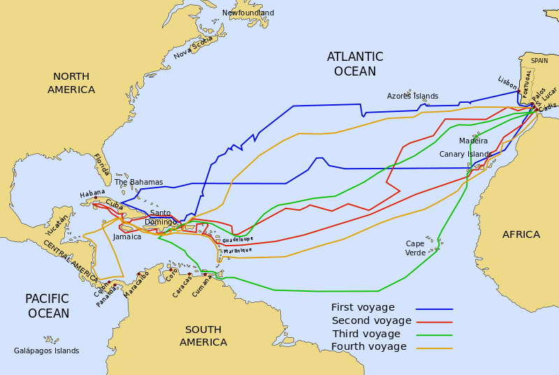
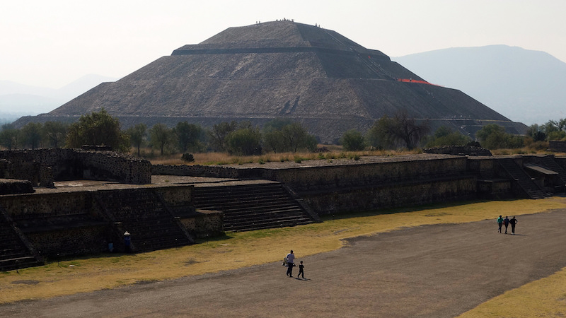

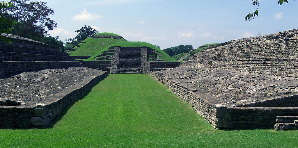
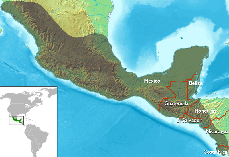
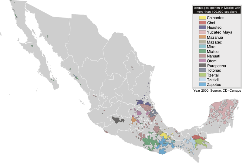
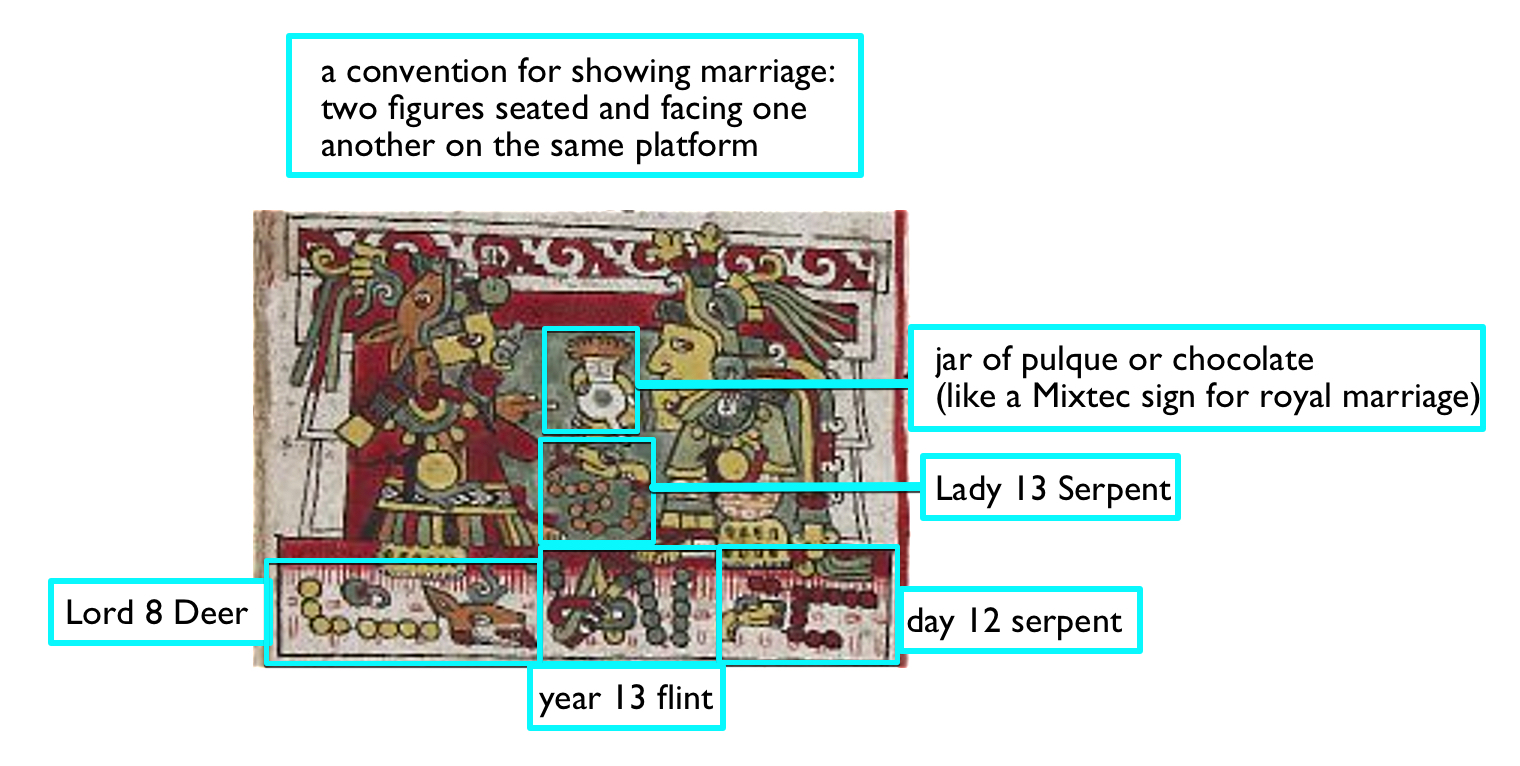
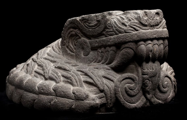
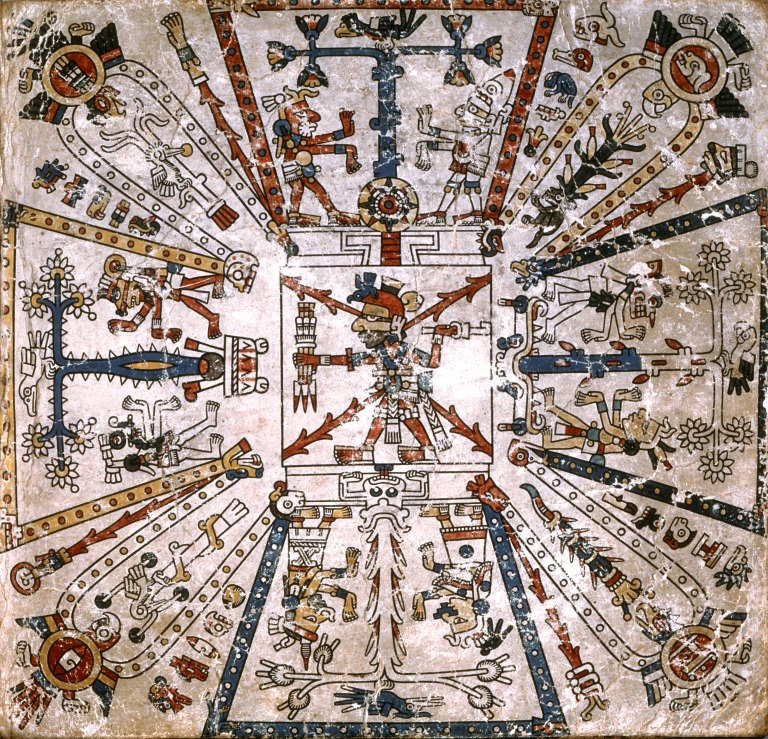
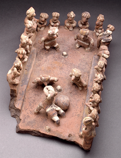
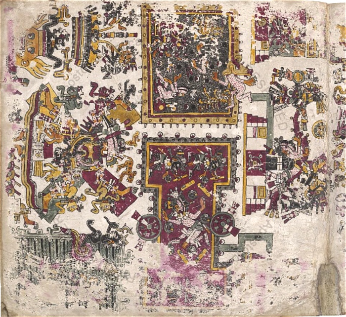


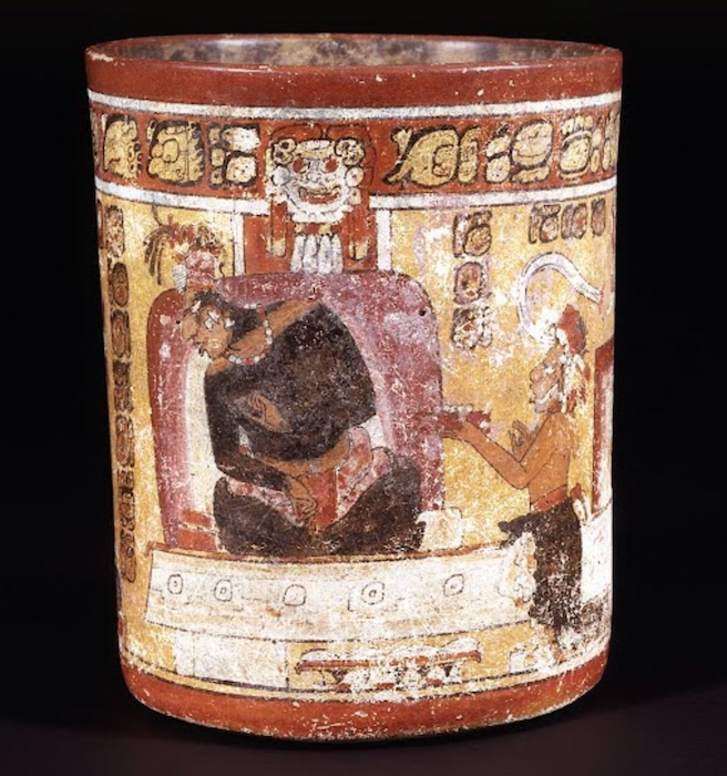


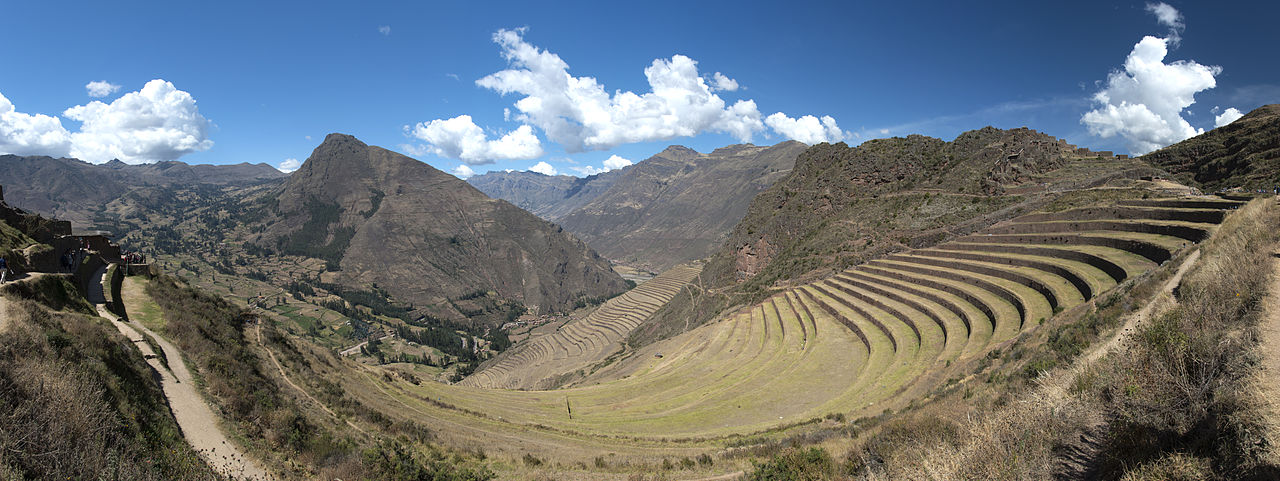
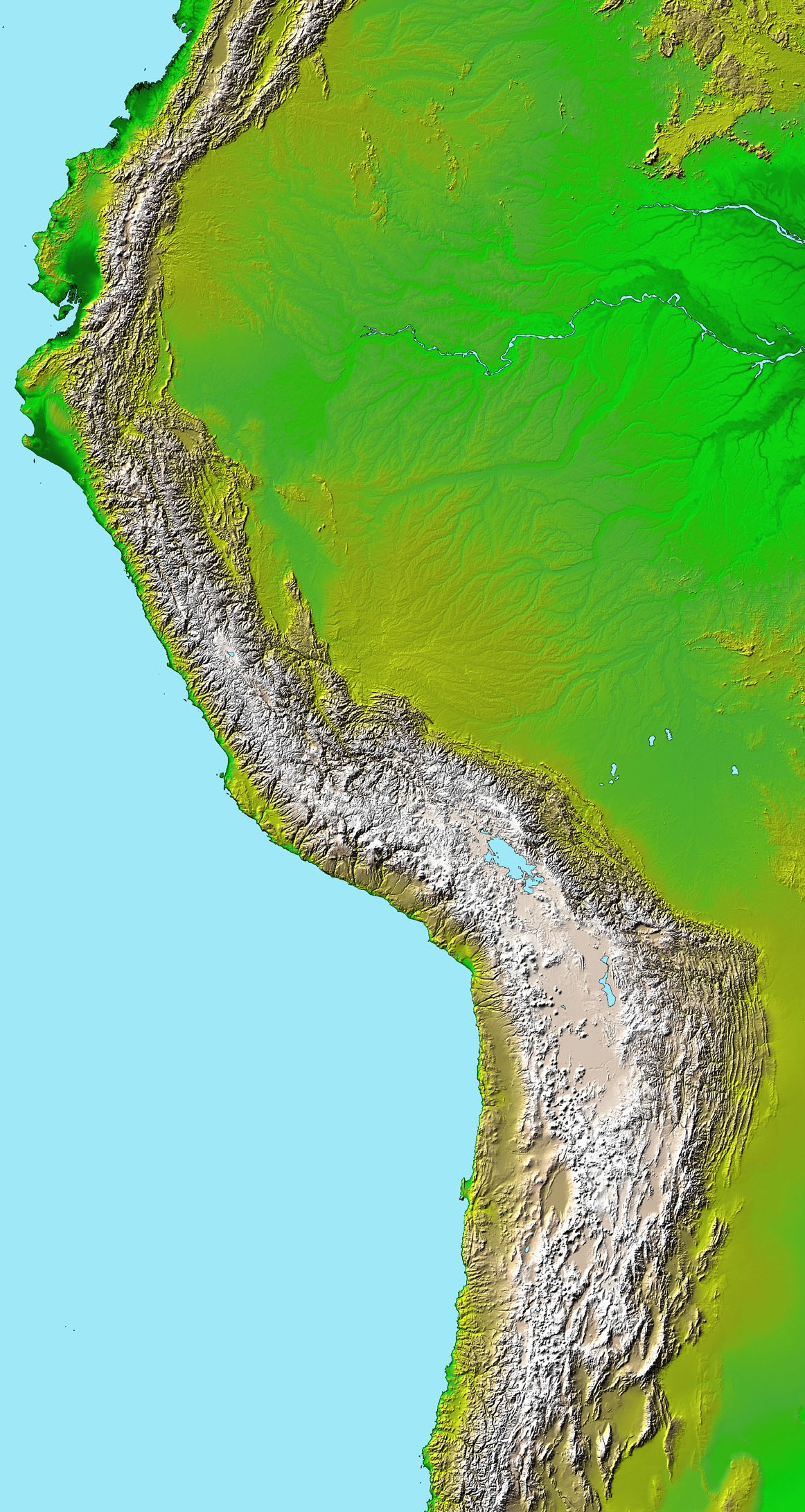
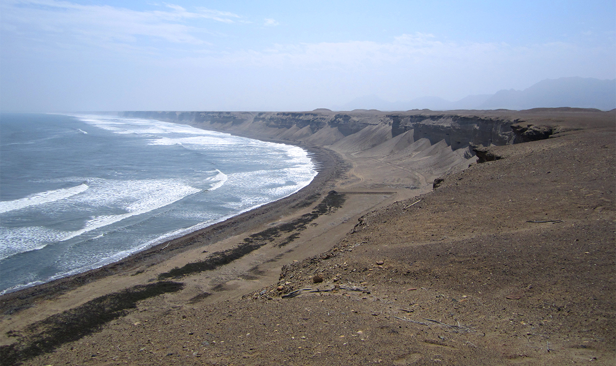

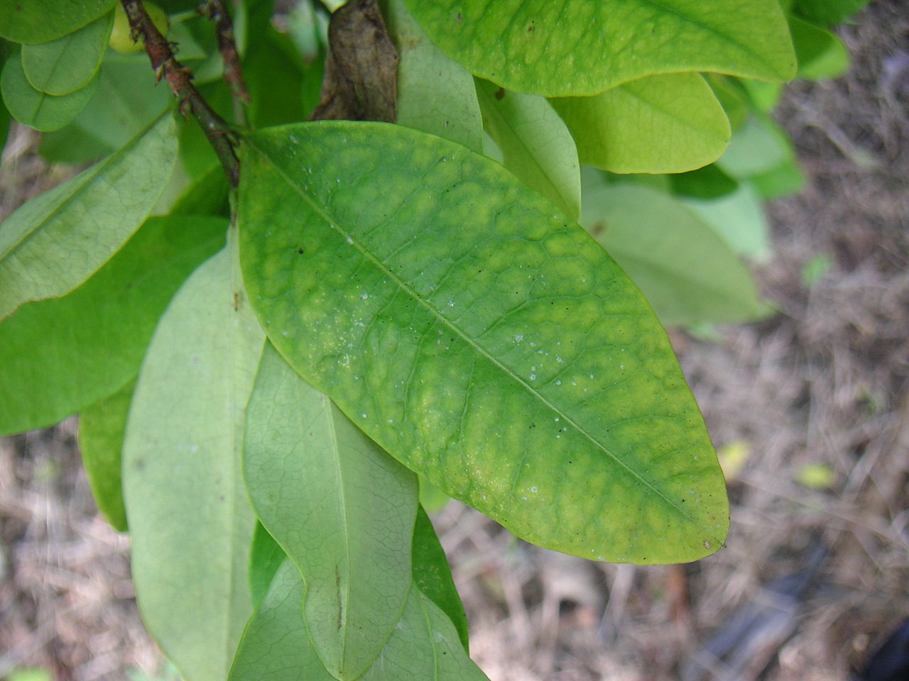
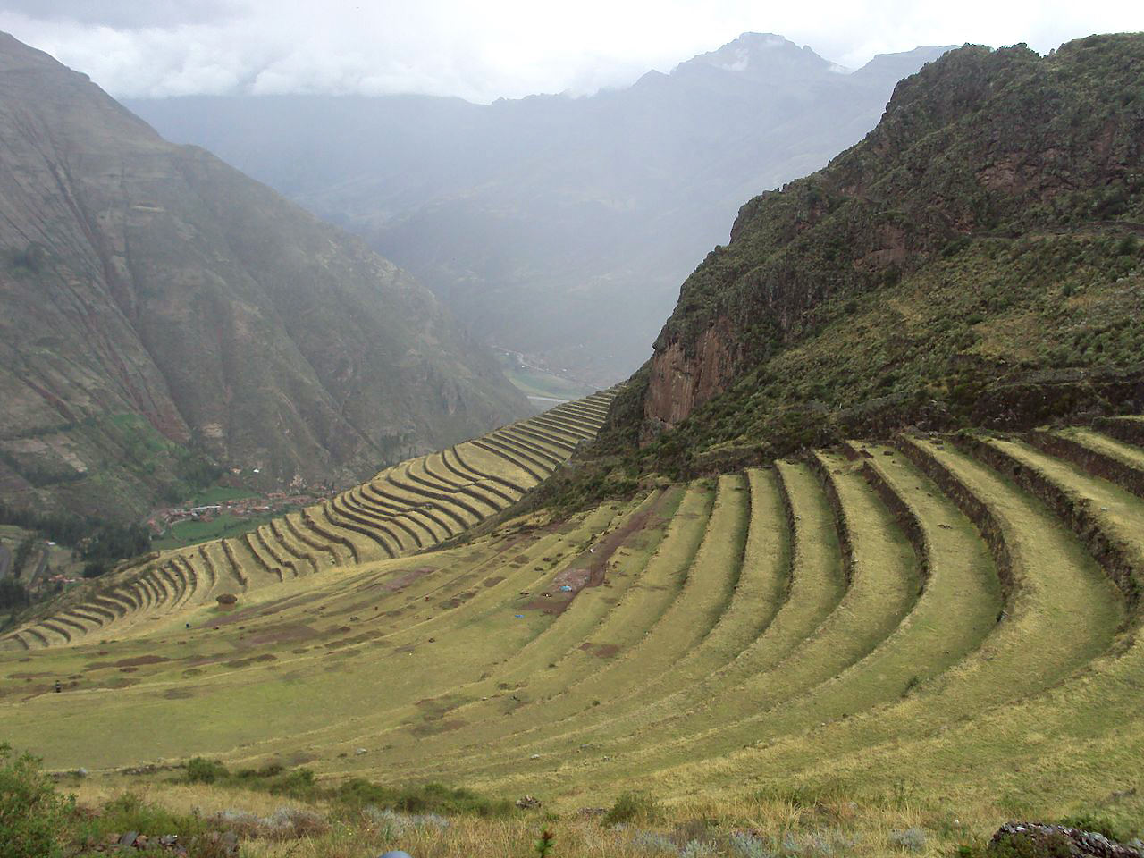
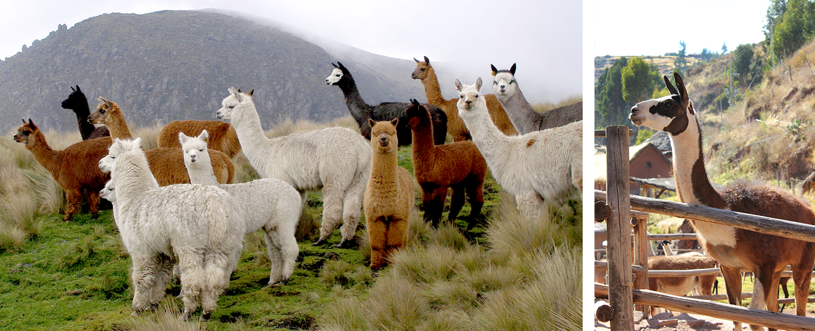
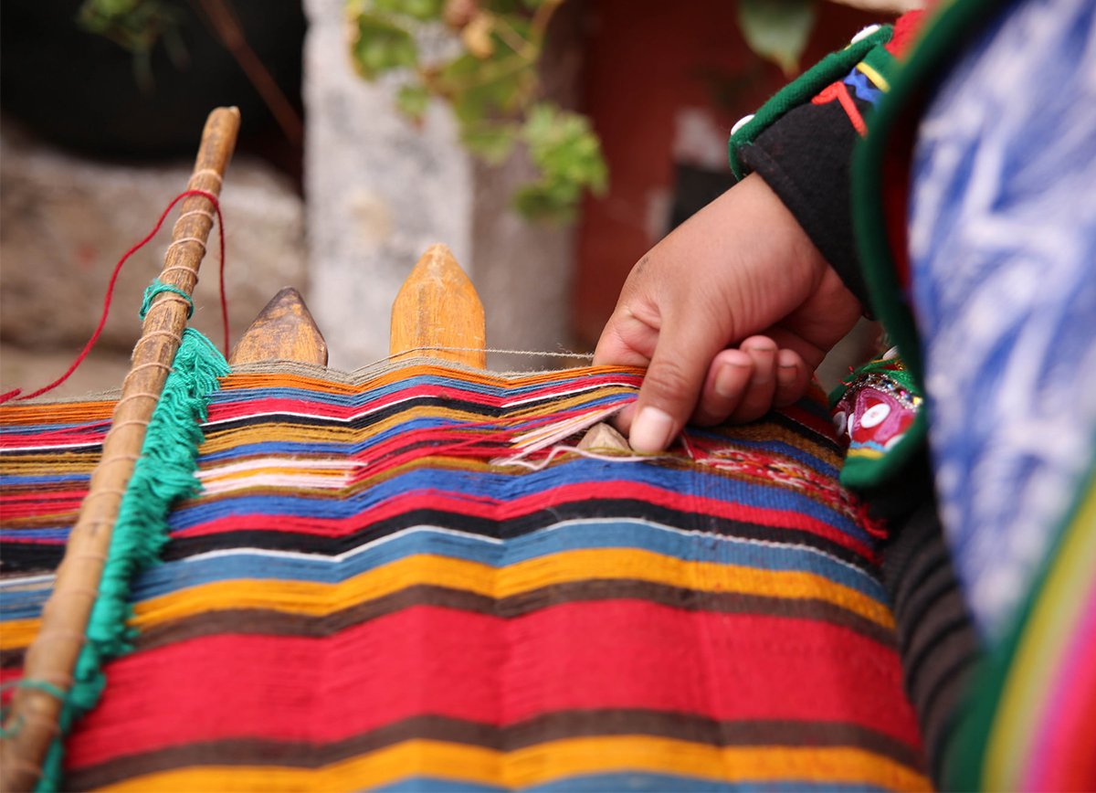
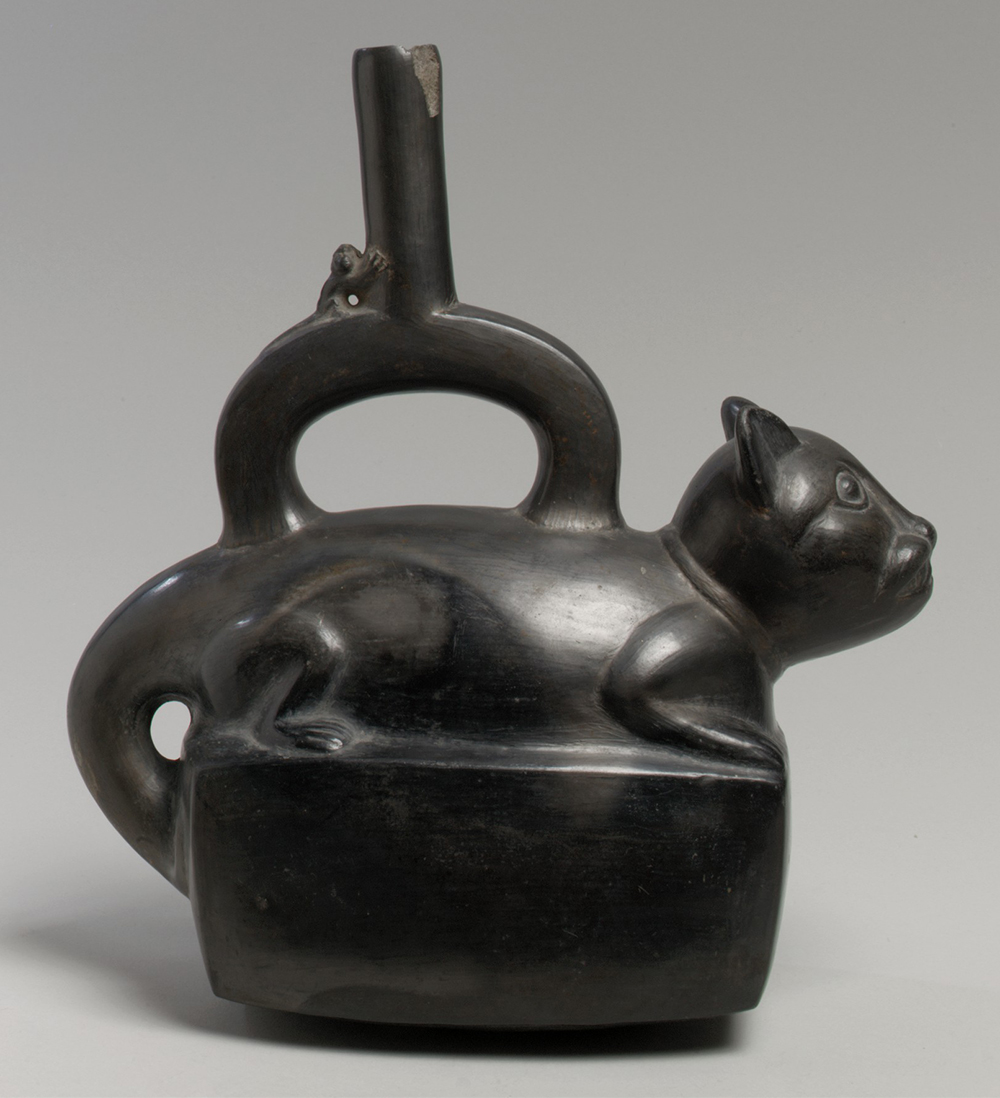
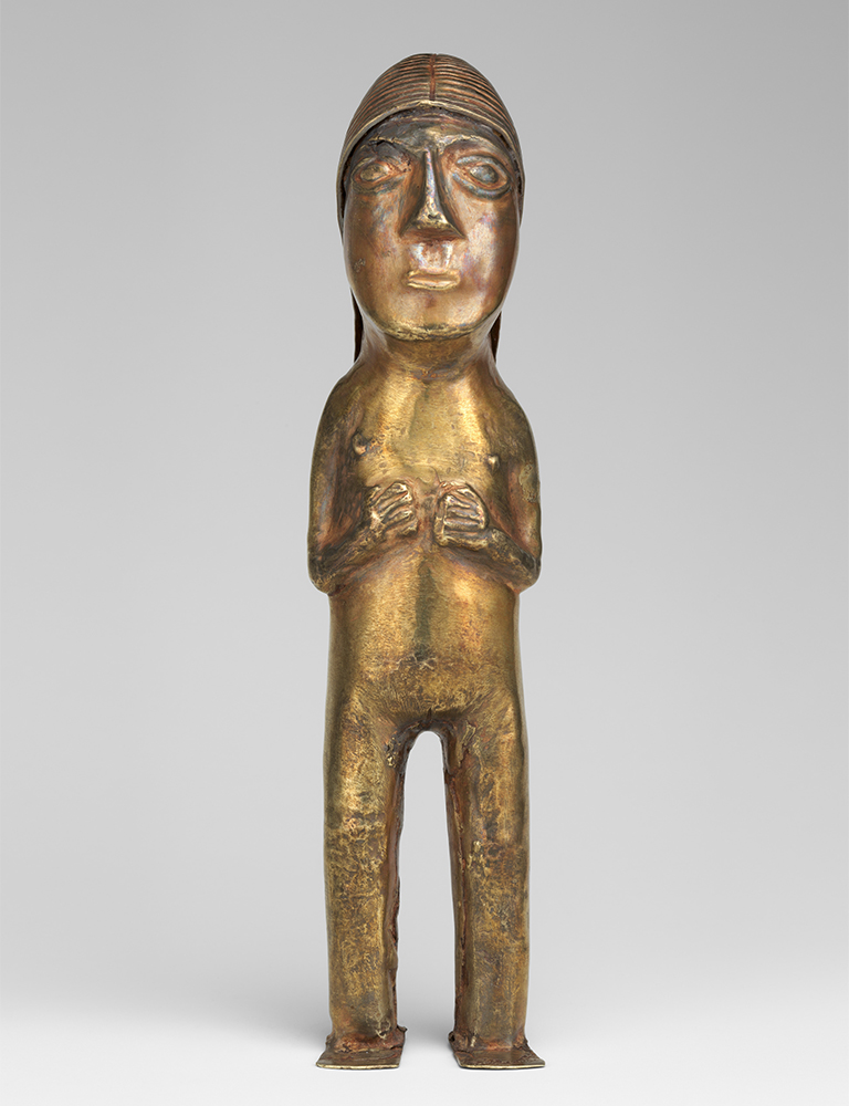
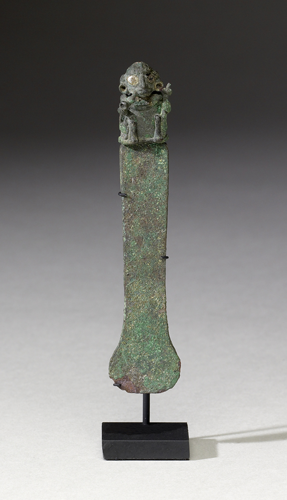
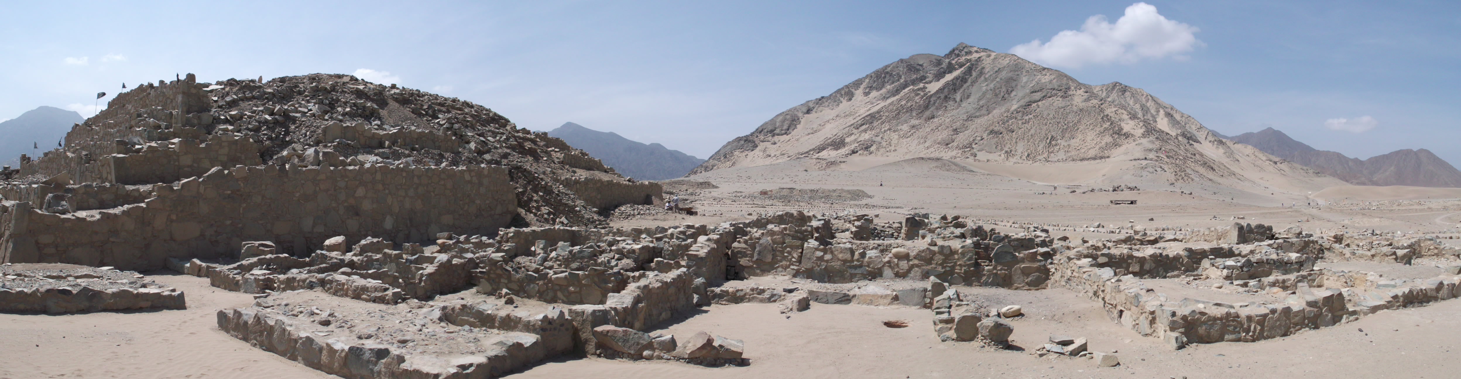
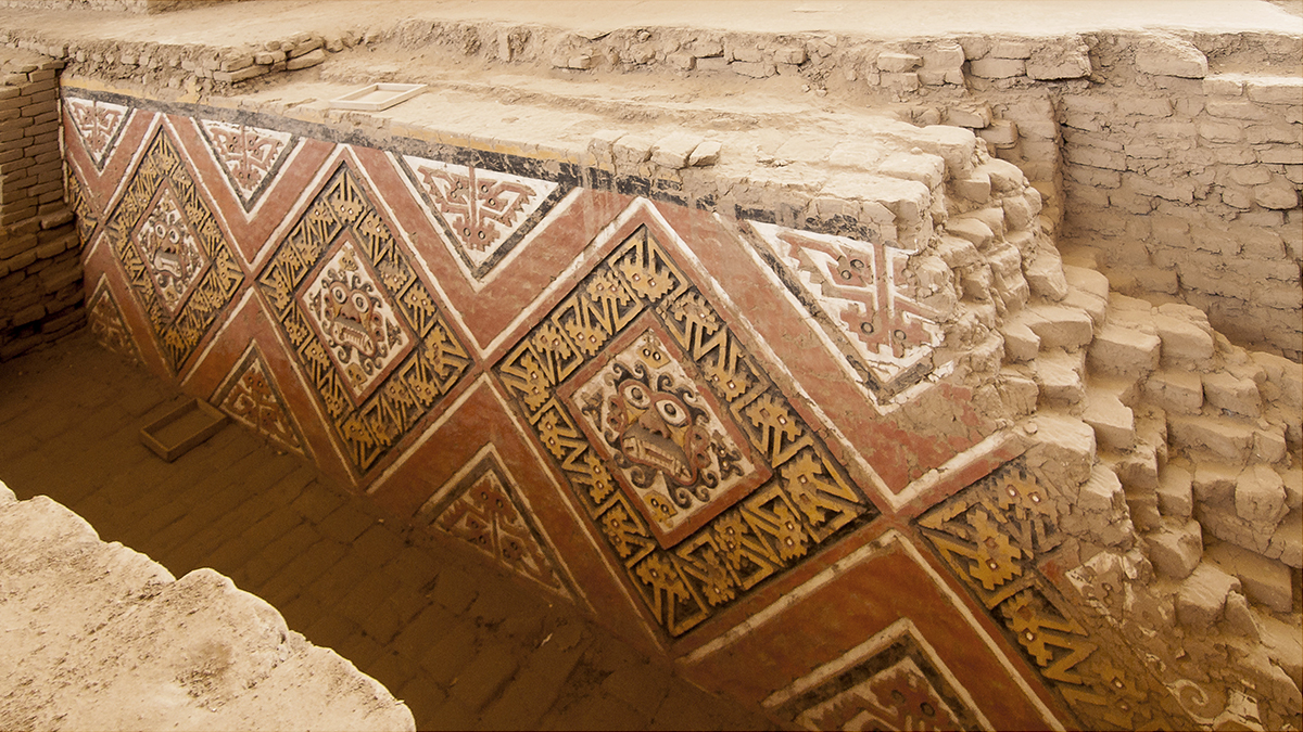
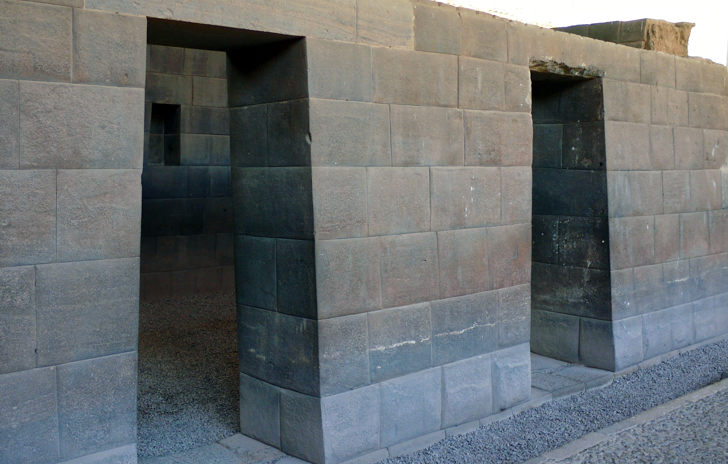
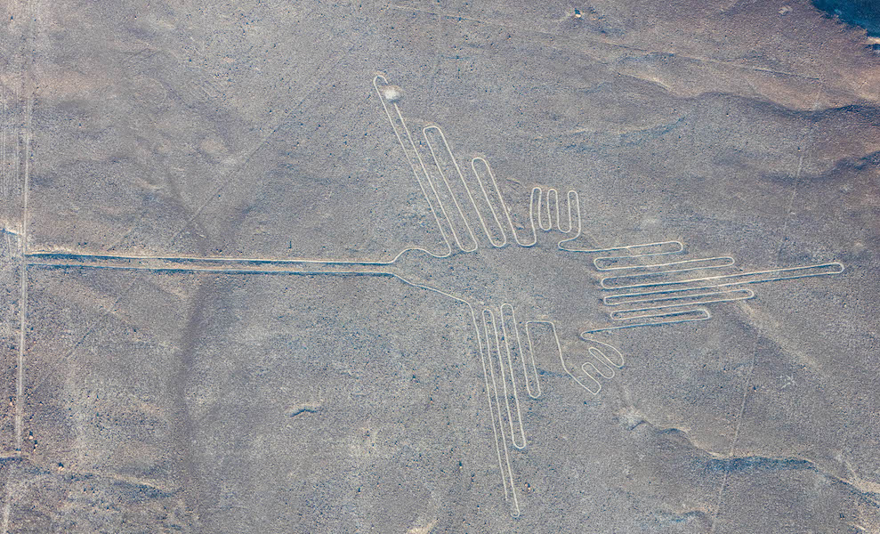
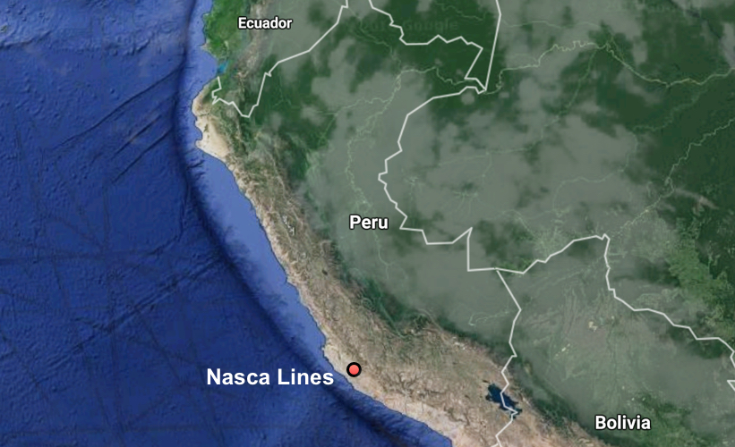
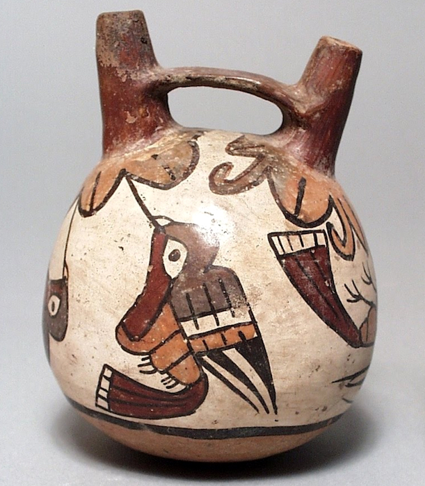
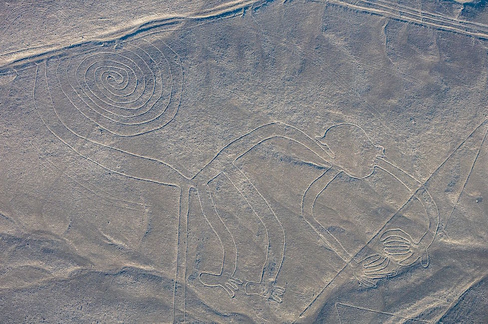
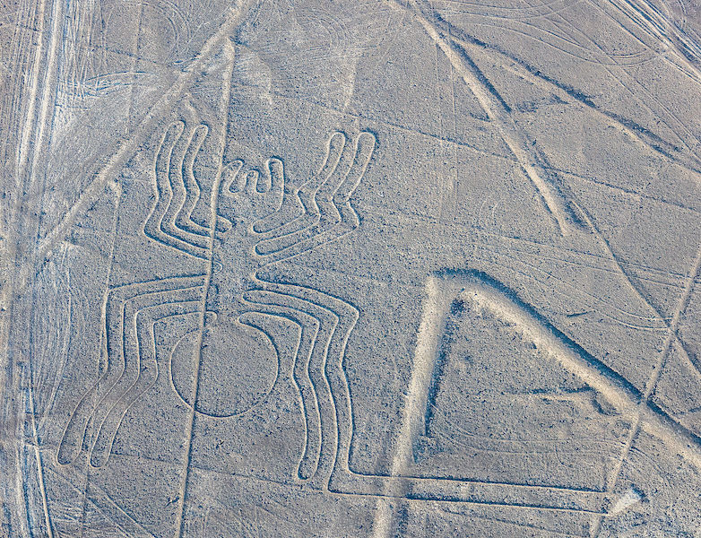
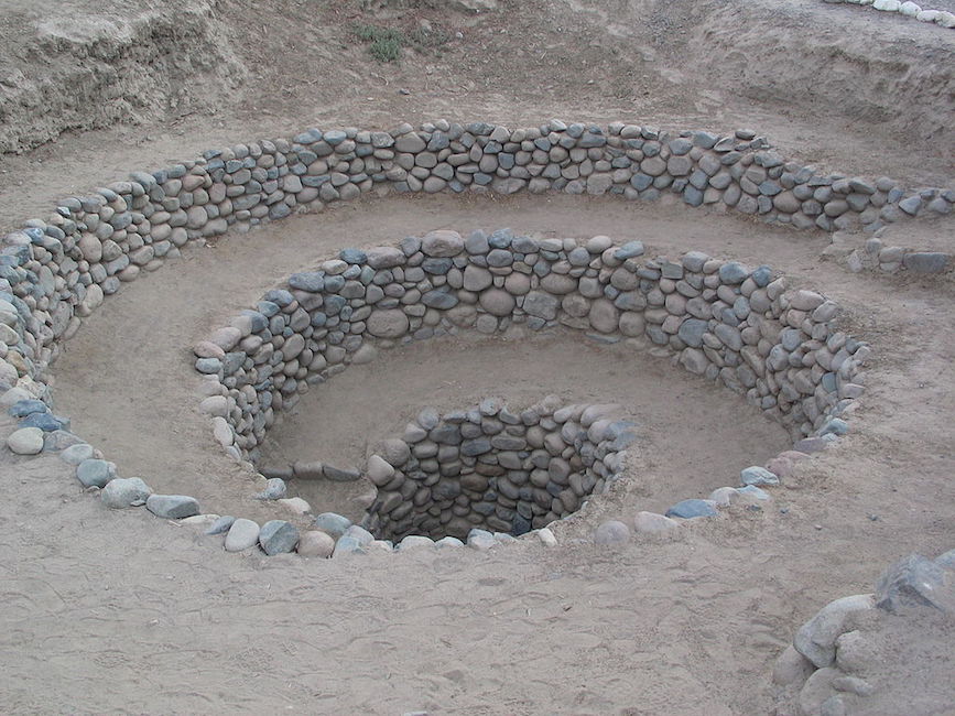


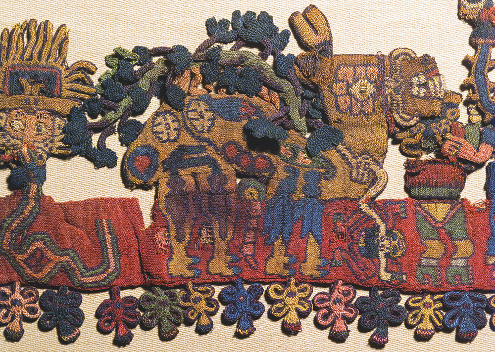


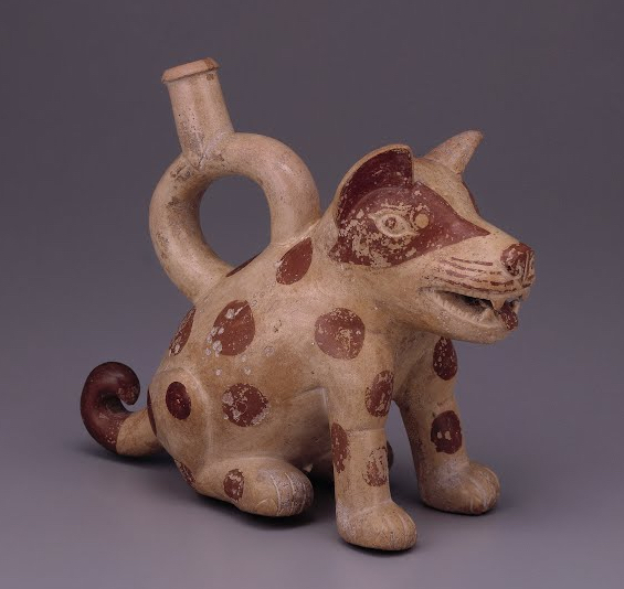

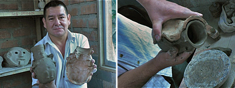
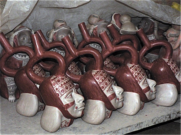
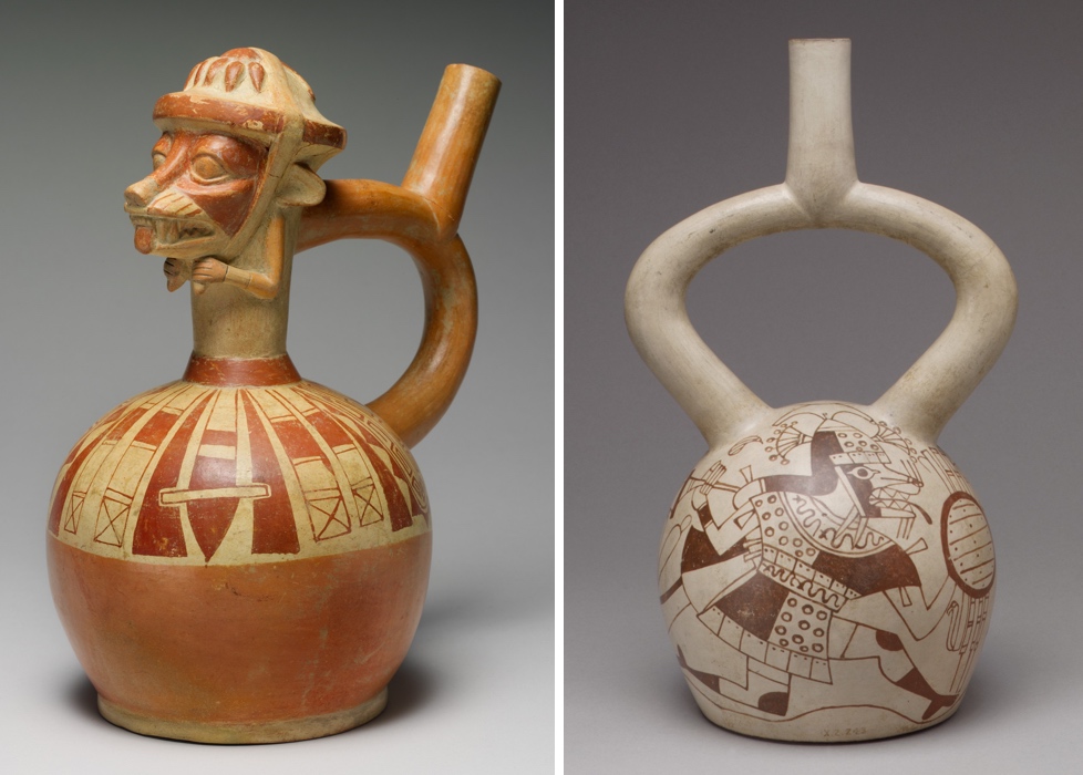
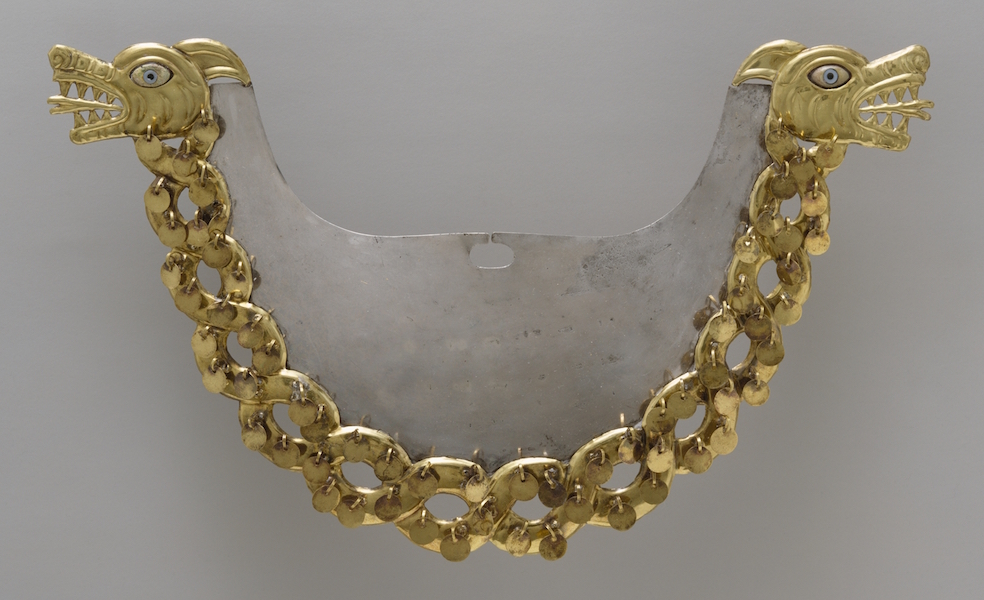
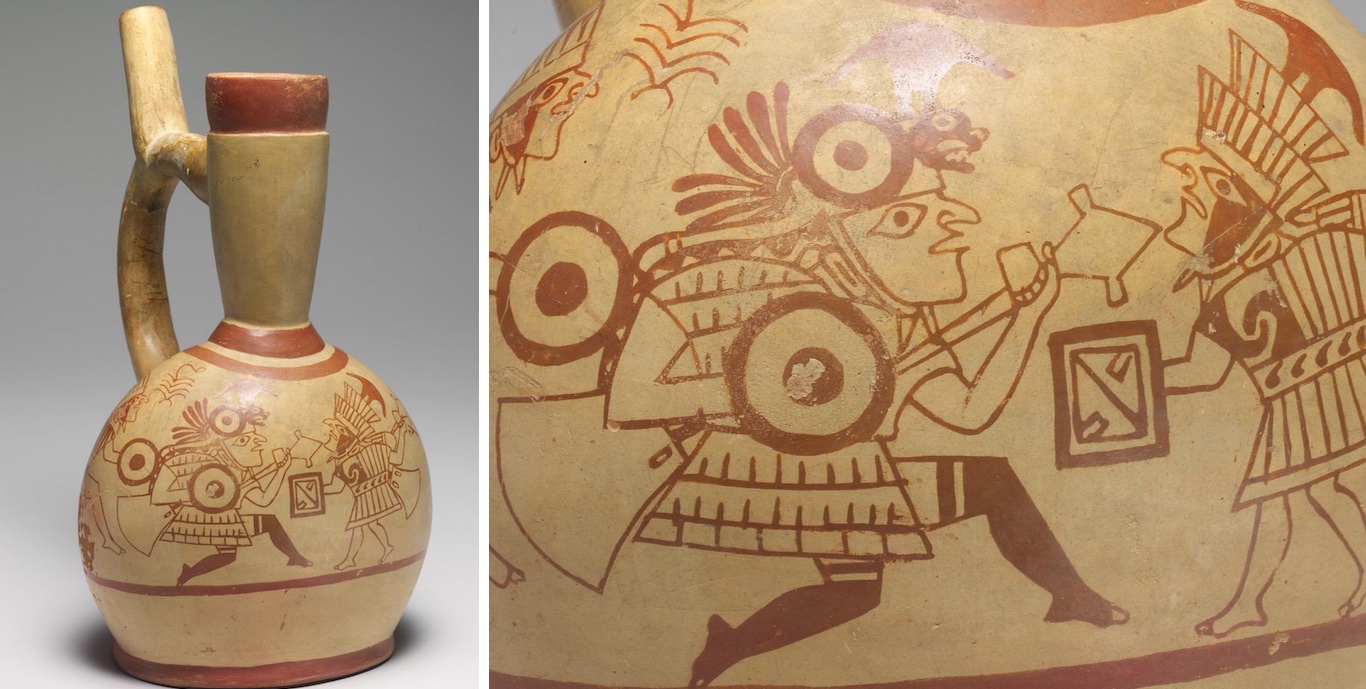
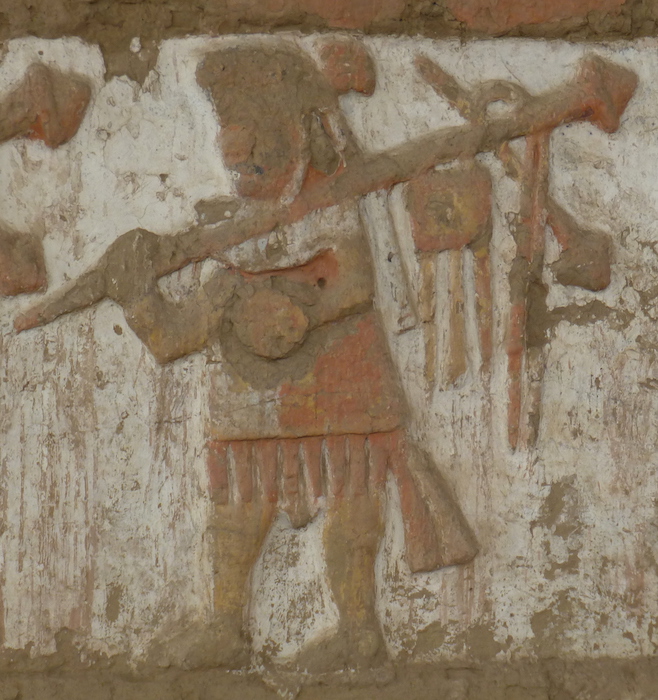
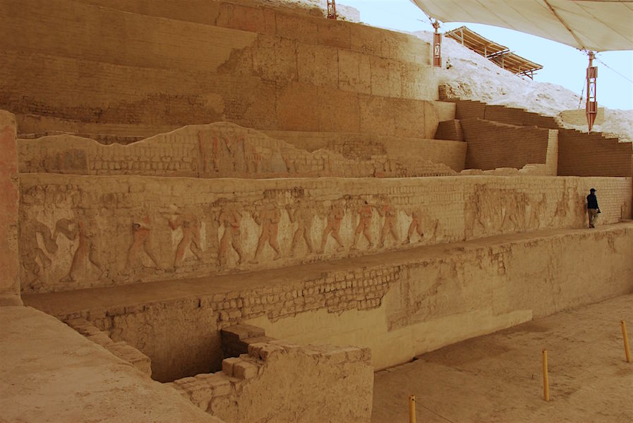


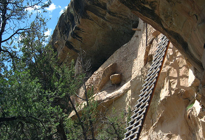


.jpg)